| |
[Aug. 31st, 2020|11:23 pm] |
Issyk-Kul is an lake in the northern Tian Shan mountains in eastern Kyrgyzstan, in the centre of Asia.
At the bottom of Issyk-Kul, the legendary ancient city of Chigu seems to have been discovered. The underwater work site is about 6 metres deep. In the crystal-clear water of Issyk-Kul, the remains can be seen even from the surface. Specialists dive several times a day, in two groups. According to scientists, in all their practice, they have not seen so many ancient objects. Every hour they work, there are kilograms of artifacts.
Иссык-Куль - озеро на севере гор Тянь-Шаня на востоке Кыргызстана, в центре Азии.
На дне Иссык-Куля, похоже, обнаружен легендарный древний город Чигу. Объект подводных работ находится на глубине около 6 метров. В кристально-чистой воде Иссык-Куля его видно даже с поверхности. Погружаются по несколько раз на дню, двумя группами. По словам ученых, за всю свою практику они не встречали такого количества древних предметов. Каждый час работы — килограммы артефактов.
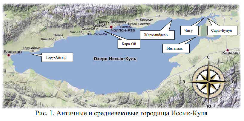
Materials from the article "Antique and medieval settlements at the bottom of Issyk-Kul":
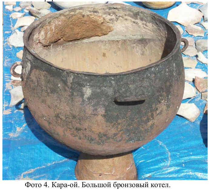
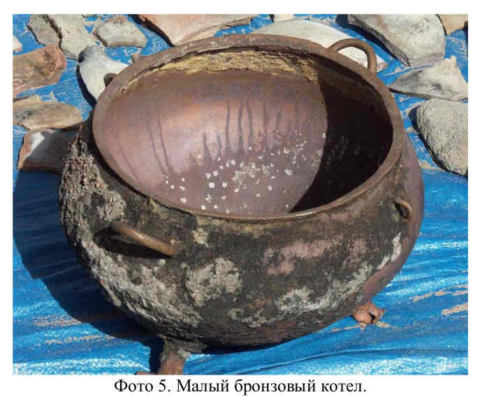
Kara-oi
In Kara-Oi Bay, 2.5 kilometres from the shore, working at a depth of 5 to 10 metres off the northern shore of the lake, we saw huge walls up to half a kilometre long underwater. This is a sign of a large city, which could be several square kilometres in size. The scale for those times is enormous. Literally on the last day of the 2003 field season, we lifted two perfectly preserved bronze sacrificial boilers from the bottom of the lake.
Материалы из статьи "Античные и средневековые городища на дне Иссык-Куля":
Кара-ой
В заливе Кара-Ой на расстоянии 2,5 км от берега, работая на глубине от 5 до 10 метров у северного побережья озера, мы видели под водой огромные стены, длиной до полукилометра. Это – признак большого города, площадь которого могла составлять несколько квадратных километров. Масштаб по тем временам колоссальный. Буквально в последний день полевого сезона 2003 г. со дна озера нами были подняты два бронзовых жертвенных котла прекрасной сохранности.
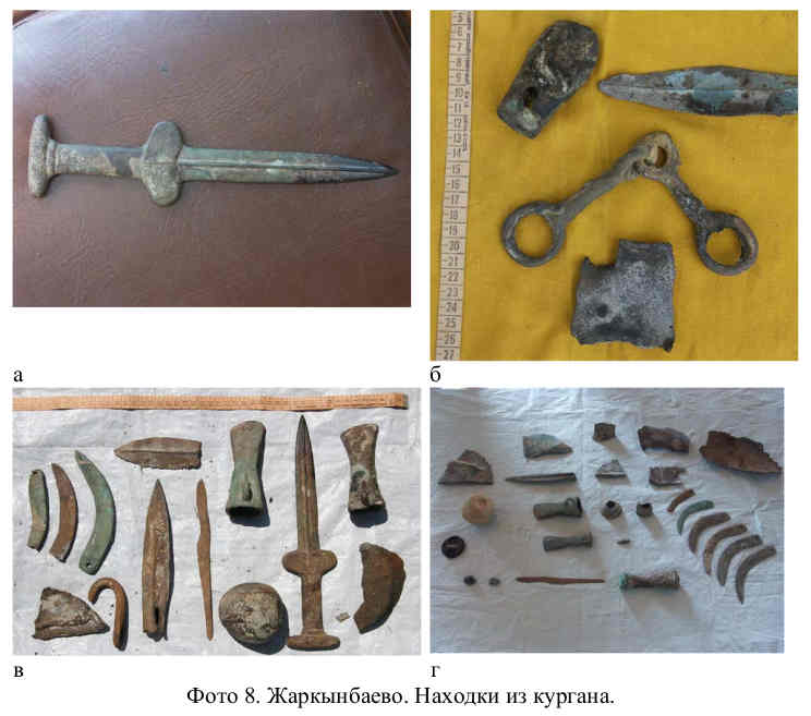
Zharkynbayevo
Unlike the previous settlement, the approach (access) to this site is associated with certain natural challenges. Remains of brickwork, ceramic water conduit, presumably from the medieval period, are encountered in this area. In particular, we found burial mounds at the bottom where Scythians were buried, washed away by the waves. The imagination and high art of processing bronze mirrors, elements of ceremonial horse harness and other items for a variety of purposes are amazing.
Жаркынбаево
В отличие от предыдущего городища, подход (подъезд) к данному объекту связан с определенными сложностями природного характера. В данном районе встречаются остатки кирпичной кладки, керамического водопровода, предположительно, средневекового периода. В частности, на дне нами были обнаружены размытые волнами курганы, в которых хоронили скифов. Поражает воображение и высокое искусство обработки бронзовых зеркал, элементов парадной конской упряжи и других предметов самого разного назначения.
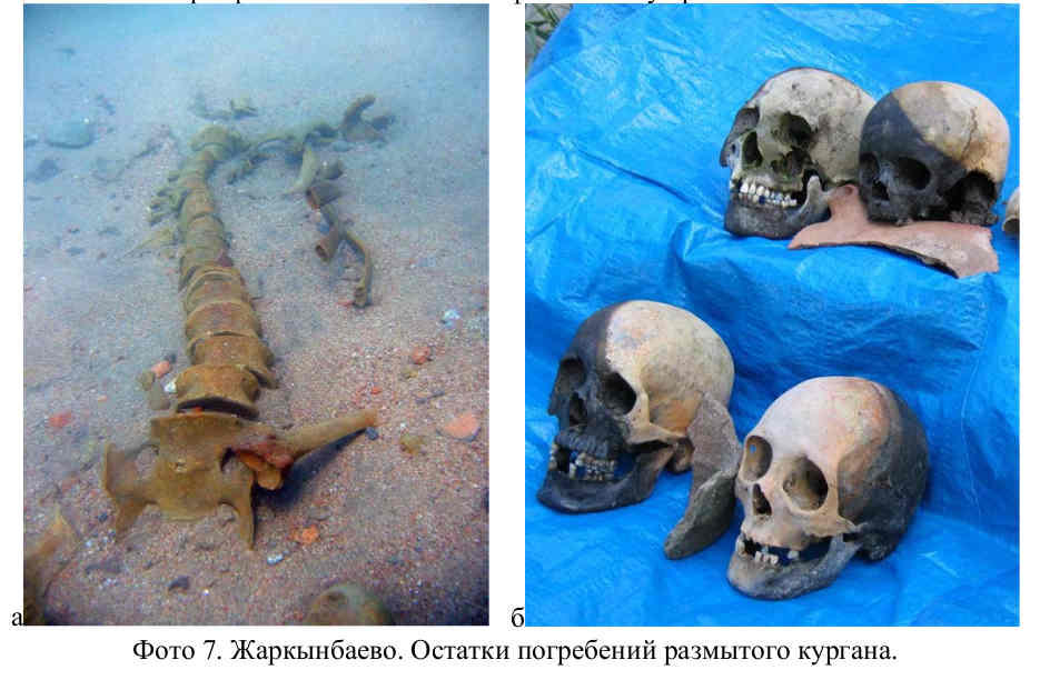
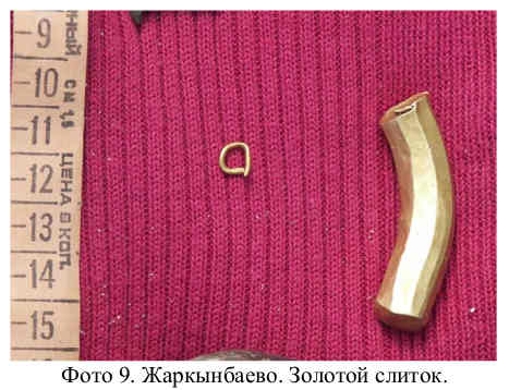
Later, an octagonal-shaped gold bar weighing almost 70 grams was raised. It can be assumed that this ingot was the first example of an early form of metal money found in Central Asia to serve as an exchange equivalent. If the hypothesis is confirmed, this discovery will not only acquire a material price, but will also become a unique historical and cultural value of world significance as a prototype of gold coins.
Позже был поднят обрубок золотого слитка проволочной восьмигранном формы, весом почти 70 граммов. Можно предположить, что этот слиток первый, обнаруженный в Центральной Азии образец ранней формы металлических денег, служивший эквивалентом обмена, – предшественник монет. Если гипотеза подтвердится, то эта находка приобретет не только материальную цену, но и станет уникальной историко-культурной ценностью мирового значения, как прообраз золотых монет.
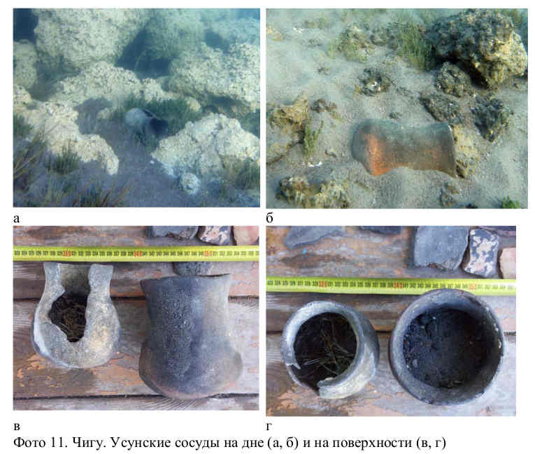
Chigu
In the 1985 field season, we first discovered the remains of a large settlement at the bottom of Tyupskiy Bay. We assumed that we had found the ruins of the famous city of Chigu, a powerful ruler of the ancient Usun tribal union on Issyk-Kul, which is mentioned in ancient Chinese chronicles.
Чигу
В полевой сезон 1985 г. на дне Тюпского залива нами были впервые обнаружены остатки крупного городища. Мы предположили, что нашли развалины знаменитого города Чигу – ставки могущественного правителя древнеусуньского племенного союза на Иссык-Куле, который упоминается в древнекитайских летописях.
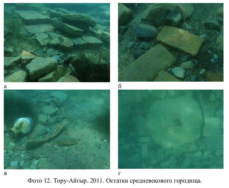
Toru-Aigyr
A large medieval settlement that has existed for several centuries. Remains of buildings made of raw bricks can be traced. Brickwork and individual bricks washed out of sand are relatively short-lived. However, the hydro regime of the lake is such that it may well be hidden into the sand again. The same applies to other artefacts. In 2011, A.Kolesnikov detected millstones. Near the flooded settlement, signs of the existence of major ritual complexes, residential buildings and household outbuildings were found.
Тору-Айгыр
Большое средневековое городище, существовавшее несколько веков. Прослеживаются остатки строений из кирпича-сырца. Кирпичная кладка и отдельные кирпичи, вымытые из песка, сохраняются сравнительно недолго. Однако, гидрорежим озера таков, что они вполне могут быть занесены песком снова. Тоже самое касается и других артефактов. В 2011 году А.Колесниковым был зафиксирован жернов. Рядом с затопленным городищем обнаружены признаки существования крупнейших ритуальных комплексов, жилых строений и хозяйственных построек.
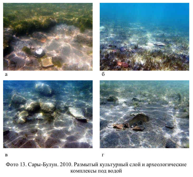
Sary-Bulun
There are traces of stone structures in the north-western and north-eastern parts. In the southern, coastal zone, there is an intensively eroded cultural layer.
Сары-Булун
В северо-западной и северо-восточной части имеются следы каменных сооружений. В южной, прибрежной зоне – интенсивно размываемый культурный слой.
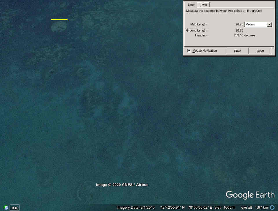
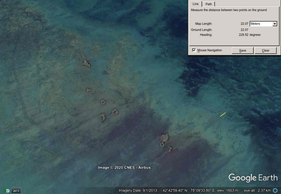
Yntymak-2
It was discovered on 27 July 2010 during another inspection of data on the presence of archaeologically significant objects. It is a part of a complex of settlements compactly located in the north-western part of the Dry Ridge Peninsula.
The ruins of the ancient settlement of Yntymak can be viewed on Google Earth in some pictures of past years.
Ынтымак-2
Обнаружен 27 июля 2010 года в ходе очередной проверки данных о наличии археологически значимых объектов. Представляет собой часть комплекса поселений, компактно располагавшихся в северо-западной части полуострова «Сухой хребет».
Руины городища Ынтымак просматриваются в Google Earth на некоторых снимках прошлых лет:
About 150 years ago, according to Semenov-Tyan-Shansky's records (first published in the USSR about 70 years ago), "a large copper boiler and several copper implements were found here, very old in shape and decoration". That is, by this time the settlements were most likely already submerged and the lake was throwing artifacts ashore.
At the same time, just 160 years ago, right before the eyes of eyewitnesses, almost two hundred square kilometres of fertile land with vast pastures and hayfields sunk at the bottom of Lake Baikal. More than a thousand wooden buildings that once belonged to four large villages at the mouths of the Selenga River found themselves under the ten-metre thick water column.
Около 150 лет назад, согласно записям Семенова-Тян-Шанского (впервые опубликованным в СССР около 70 лет назад), здесь были найдены «очень древний по форме и украшениям больших размеров медный котел и несколько медных орудий». То есть к этому времени, скорее всего, поселения были уже затоплены и озеро выбрасывало артефакты на берег.
При этом, всего 160 лет назад, прямо на глазах очевидцев почти двести квадратных километров благодатных земель с обширными пастбищами и сенокосами оказалось на дне Байкала. Под десятиметровой толщей студеной воды оказались более тысячи деревянных построек, принадлежавших когда-то четырем большим деревням в устьях Селенги.
#antiquity #archeology #artifact #asia #catastrophism #climatechange #deluge #flood #issykkul #kyrgyzstan #lake #memory #past #revision #timespace #stan #weather
originally posted on ussr.win |
|
|