[Most Recent Entries] [Calendar View] [Friends]
Below are the 20 most recent journal entries recorded in
iv_g's LiveJournal:
| Tuesday, January 18th, 2011 | |
| 10:00 am | |
| Thursday, January 13th, 2011 | |
| 2:30 pm | North Dakota Tops 350,000 Bbls/Day, Could Double by 2015  North Dakota pumped another record amount of oil in November, at an average daily rate of 355,038 barrels, which is double the amount of oil produced as recently as the summer of 2008, and 44% higher than a year ago data here https://www.dmr.nd.gov/oilgas/stats/his Experts predict that production could double to 700,000 barrels per day within four to seven years in the Peace Garden State, which would put North Dakota ahead of both Alaska and California, and second only to Texas in oil production for American states. http://mjperry.blogspot.com/2011/01/n |
| Monday, January 10th, 2011 | |
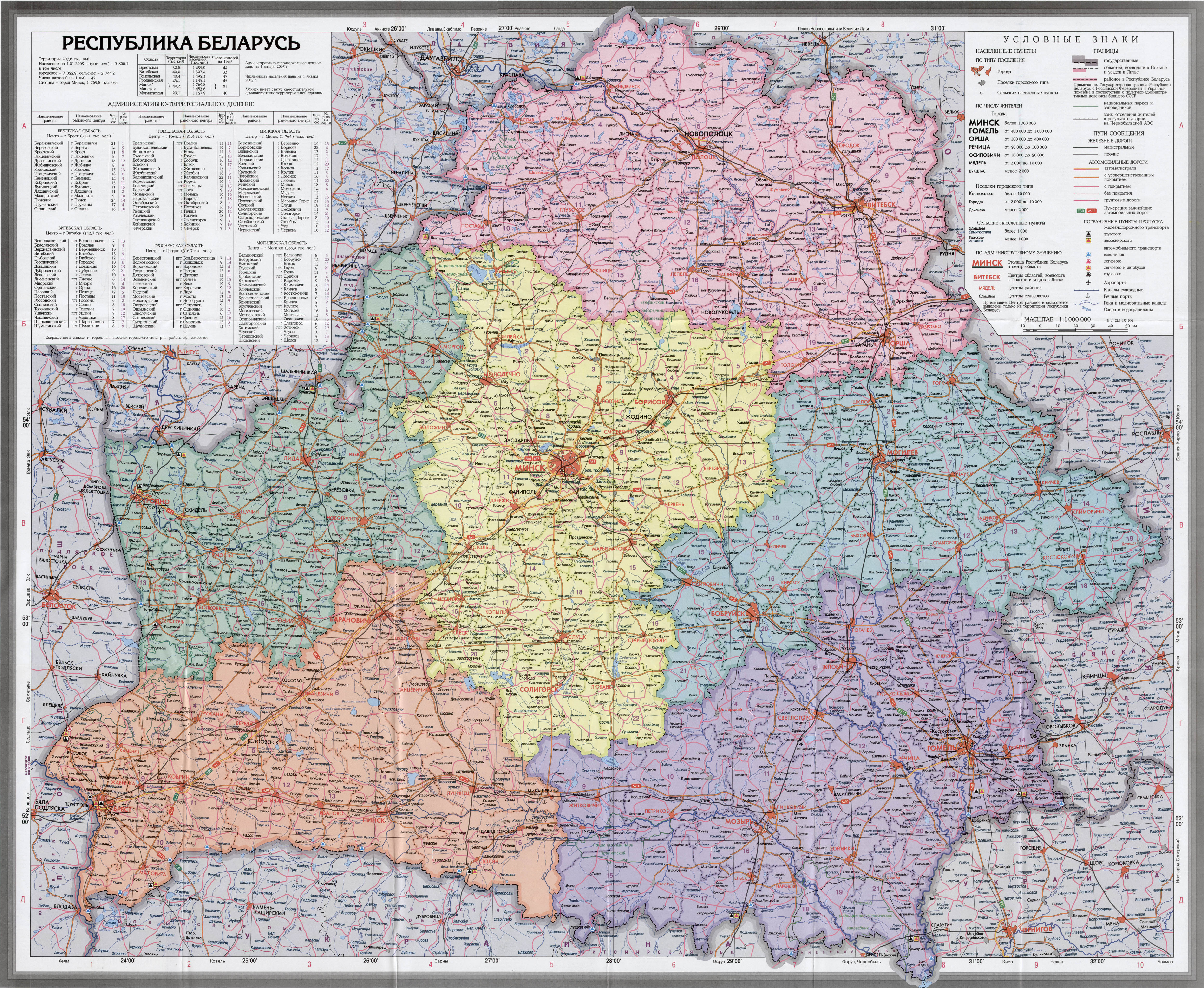
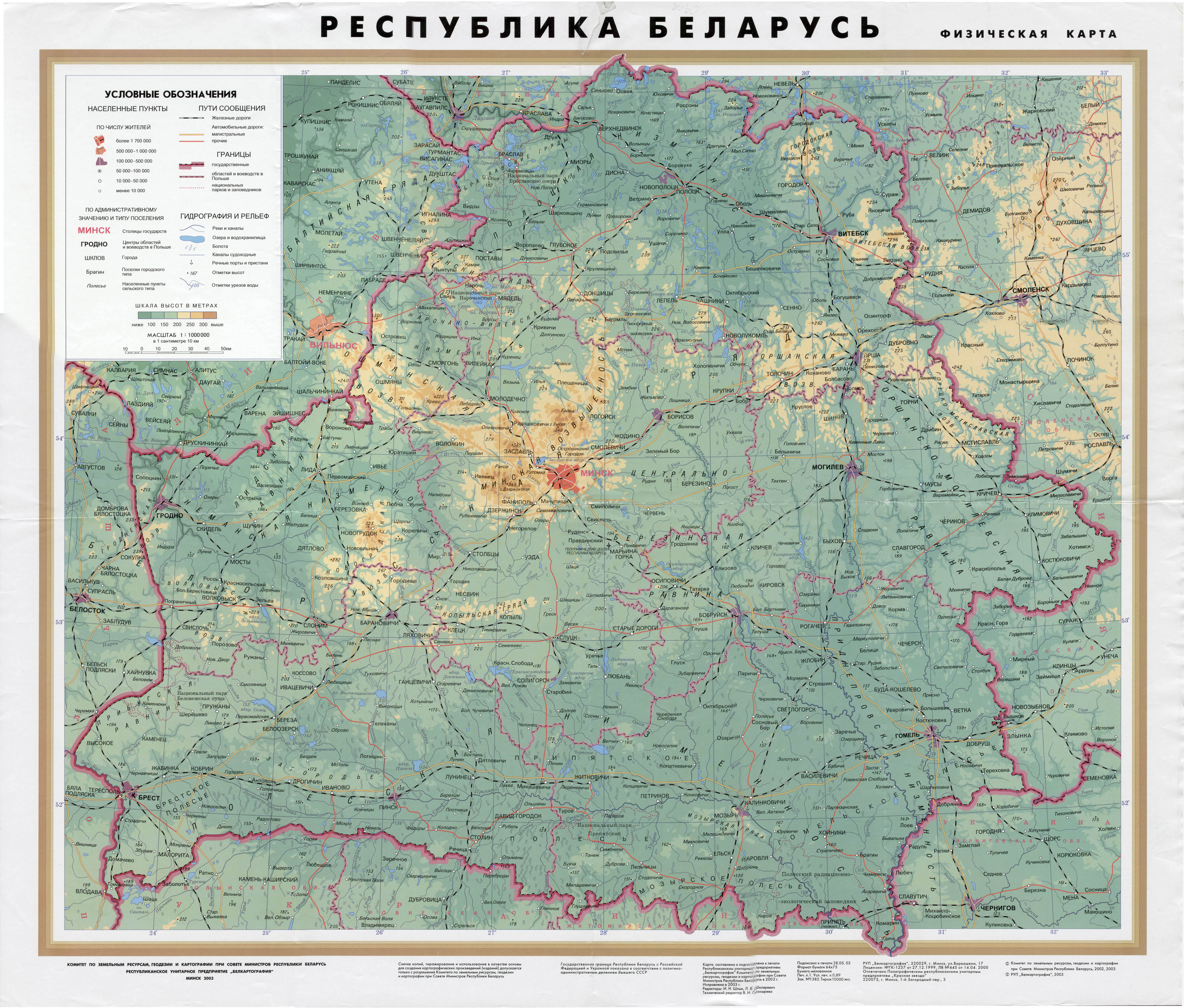
| 10:05 am | Белоруссия: геология, нефть и газ Экономика Белоруссии очень мало месторождений углеводородов: добыча нефти из полесских месторождений в районе Речицы за год не превышает 1,5 млн тонн. Топливно-энергетический комплекс Белоруссия практически полностью зависит от внешних поставок энергоносителей. В то же время она располагает двумя нефтеперерабатывающими заводами, построенными в советские времена, — Мозырским и Новополоцким. Производственные мощности были частично модернизированы с учётом требований европейского рынка. Одновременно происходило постепенное увеличение объёмов нефтепереработки (с 12 млн т в 2001 г. до 20 млн т в 2006 г.) и соответствующий рост экспорта нефтепродуктов (почти в 5 раз с 2002 по 2006 гг., когда он составил $7,5 млрд). До конца 2006 года Белоруссия имела возможность закупать нефть в России по внутренним российским ценам и экспортировать нефтепродукты по мировым ценам, что позволяло не только удовлетворять внутренние потребности страны в нефтепродуктах, но и получать значительные доходы. При этом расходы на газоснабжение частично компенсируются за счёт реэкспорта российского газа и в этой ситуации Белоруссия, при почти полном отсутствии своей нефти и газа, не пострадала, а выиграла от роста мировых цен на энергоносители. В 2005 году потребление топливно-энергетических ресурсов (ТЭР) достигло 34,9 млн т. у.т. В структуре потребления ТЭР 59,9 % занимает природный газ, 21,7 % — нефтепродукты и сырье, 0,7 % — уголь, 15 % — местные виды топлива (торф, дрова), 5,7 % — импорт электроэнергии. ( Read more... ) Добыча горючих полезных ископаемых В стране разрабатывается несколько нефтяных месторождений, все они относятся к Припятской нефтегазоносной впадине, на 2000 год промышленные запасы месторождений оцениваются в размере 63 млн т., попутного газа 35 млрд м³, неразведанные — 190 млн т. и 90 млрд м³ соответственно. в 2009 году в Беларуси было добыто 1.720 тыс. тонн нефти. Всего насчитывается 74 нефтяных месторождения, расположенных в тектонической зоне Припятского прогиба (в Гомельской и части Могилевской и Минской областей). На начало 2010 г. разрабатываются 59 месторождений, 9 месторождений — разведываются, 50 месторождений — эксплуатируются. По состоянию на начало 2010 года, по словам директора ГП «БелНИГРИ» Александра Лобова, промышленные остаточные запасы нефти в Беларуси составляют более 50 млн тонн. Половина запасов — трудно извлекаемые. На текущий момент начались работы по поиску нефтяных месторождений в южной части Припятского прогиба. С целью реализации нефтепродуктов в мае 2007 года создана Белорусская нефтяная компания. По словам белорусского заместителя министра природных ресурсов и охраны окружающей среды Анатолия Лиса, в 2010 году планируется увеличение запасов нефти на 950 тыс. тонн. Ранее, в 2009 году был обеспечен прирост нефтяных запасов на 1 млн. 673 тыс. (из них 419 тыс. тонн было разведано РУП «Белгеология» и 1 млн. 254 тыс. тонн РУП "ПО «Белоруснефть». Ранее, в 2004 году, добыча нефти составила 2 млн т. нефти и 250 млн м³ газа. ( Read more... ) Отмечаются запасы горючих сланцев в промышленных запасах — 3 млрд т. (эквивалентных 660 млн т.у.т.) и бурых углей в размере 150 млн т. (28 млн т.у.т.). Технический ветропотенциал оценён в 300—400 (согласно источнику — более 288) млрд кВт·ч/год, однако в силу преобладания ветров малой скорости экономический потенциал значительно ниже. http://ru.wikipedia.org/wiki/Эконом  ( 5000×4104 ) http://maps.vlasenko.net/belarus/by-a  ( 5000×4257 ) http://maps.vlasenko.net/belarus/by-phi http://maps.vlasenko.net/belarus/  http://maps.grida.no/go/graphic/belarus Геология СССР. Белорусская ССР http://rogov.zwz.ru/Manuals&Classica/Geology_of_USSR/Geology_of_USSR А.А. Махнач. Введение в геологию Беларуси. Мн.: Ин-т геол. наук НАН Беларуси, 2004, 198 с. Белорусский геологический портал - Геология Беларуси http://www.geology.by/ The Mineral Industry of Belarus http://minerals.usgs.gov/minerals/p Геологическая карта 1 : 5 000 000  http://www.geologiya.org/index.php?p=ga Инженерно-геологическая карта Беларуси  http://geology.by/geomaps/28.html?p http://geology.by/images/geolog/map Месторождения полезных ископаемых  http://geology.by/geomaps/28.html?p http://geology.by/images/geolog/map Карта нефтегазогеологического районирования  http://www.geologiya.org/index.php?p=ga http://www.geologiya.org/index.php?p=ga Министерство природных ресурсов и охраны окружающей среды Республики Беларусь http://minpriroda.by/ru/ Геологоразведочное республиканское унитарное предприятие "Белгеология". http://www.geologiya.org/ http://belgeologiya.orfica.com/index.ph Закрытое Акционерное Общество «Белруснефтегаз», головное предприятие инвестиционно-промышленной группы «БЕЛРУСНЕФТЕГАЗ», специализируется на добыче и переработке нефти и газа, сооружении «под ключ» объектов нефтегазового комплекса и энергетики, строительстве трубопроводов различного назначения, промышленно-гражданском строительстве, реализации инвестиционных проектов. http://belrusng.ru/page1.htm Беларуськалий http://www.kali.by/russian/bel_main.htm Oil shale in Belarus http://en.wikipedia.org/wiki/Oil_shale_ Нефть Беларуси, история http://iv-g.livejournal.com/104448.h http://www.beloil.by/ru/about/  Total Oil Production  Crude Oil Production  Net Export/Imports(-)  Proved Reserves (Billion Barrels)  NG Production  NG Consumption  NG Net Export/Imports(-)  http://tonto.eia.doe.gov/country/countr |
| 8:00 am | Natural Gas Pricing and Its Future: Europe as the Battleground Московский центр Карнеги http://carnegieendowment.org/files/gas_ |
| Monday, January 3rd, 2011 | |
| 6:44 pm | abcdefgh: социальные сети типа FaceBook В чем причина того, что более поздние социальные сети типа FaceBook так легко и быстро обошли по своей популярности исторически более ранние: livejournal и пр.? Каковы - недостатки livejournal - неизвестные в эпоху рождения lj преимущества Facebook, Twitter ... Уточнение: Вопрос относится именно что к техническим / фукциональным особенностям сопоставляемых сервисов - и только к ним - а не к бизнес-моделям того или иного периода их развития и прочим вне-техническим областям, как скажем особенностям взаимоотношений с пользователями / инвесторами и др. http://abcdefgh.livejournal.com/1312956.h - - - - - - - - - - - - - - - Комментарии: - livejournal - это блоги. твиттер и фбук - совсем нет, функциональность совершенно другая. - в фбуке очень неудобно вести дневник, но, наоборот, все заточено на виртуальное общение: группы, мессджи на стене, чат, игры, правильно сделанный фотоальбом, индикация, кто из друзей в настоящее время доступен, и т.п. аналогичный функционал присутствует и в других соцсетях, менее успешных. ливжурнал же лишь система связанных блогов, не более того. - lj: Хочется что то сказать людям и услышать их мнение. Свою точку зрения пытаешься обосновать насколько это возможно. А твиттер для раскрученного пижона. Брякнул афоризм. пошутил, получил "вау" от поклонников. Фейсбук для своих тусовок, в поисках замужества или ... Для кинодивы и для раскрученного политика - твиттер самое то. - В Фейсбуке у тебя есть множество инструментов помогающих "заявить о себе" 2-3 кликами мышки. Загрузить фото, нажать кнопку "лайк", добавить аппликацию, расшарить видеоклип и т.п. Статусы обычно короткие. Одна-две фразы и всё. Длинных текстов и развёрнутых статей, которых мног в ЖЖ там просто нет. Точнее возможность их писать есть, но их никто не читает. А ЖЖ стимулирует писать и комментировать в больших объёмах, что лень для большинства пользователей которые предпочли Фейсбук. - количественно спрос на функцию "заявить о себе 2-3 кликами" намного выше, чем спрос на почитать что-то интересное. - Twitter это вообще не социальная сеть. Это странный механизм которым можно хоть кашу есть хоть в носу ковырять. Типичное применение: новостная лента составленная пользователями в том числе с новостями самих пользователей, чат, менеджер закладок. В качестве блога Также отлично подходит для дешевого мониторинга оборудования: навесил GSM-сигнализацию и созерцай температуру в батареях на даче, отключения электричества или любые другие события. Связка GSM-контроллер - Twitter ничего не стоит, а удобство дает неимоверное. Facebook это именно социальная сеть. Наверное там и блог можно вести, но это как левой пяткой правое ухо чесать. ИМХО решает три задачи: секс; поддержание контакта с людьми, меняющими e-mail, тел. и место жительства чаще чем ты им звонишь; убить рабочее время (наличие "приложений" - разного рода игр, свои достижения в которых можно публиковать здесь же.) - как по мне, то любой продукт (будь то программа, устройство или идеология) изначально стает популярным в результате сужения функциональности. по мере набора популярности он расширяет функциональность, пока окончательно не размывает свое предназначение и модной фишкой не стает очередной ограниченный продукт. с этой точки зрения нужно смотреть что ограничивал тот или иной сервис на заре своей попрулярности. 1. твиттер - ограничение на длину символов и исключительная текстовость, что делало его функциональной заменой СМС. 2. Фейсбук - ограничение псевдонимности, в результате чего пользователь стирал свою приватность, что кстати на заре сети было дикостью и презиралось. 3. ЖЖ - изначально сервис рос за счет (как не абсурдно) ограничения участия (инвайты). - Кстати, по этому методу можно клепать стартапы. Задаем себе три вопроса: 1. какому стандартному продукту я могу обрезать функциональность? 2. как я могу это реализовать? 3. какие негативные последствия этого обрезания я могу выдать за удволетворение потребности. - Позднее, как правило, более успешно, поскольку а) учится на ошибках предшественников, б) туда закачиваются большие средства. Последнее может быть неочевидно, тут механизм такой: по мере уменьшения новизны, уменьшаются и риски. Сервисы интернет-дневников, по большому счету, даже в рунете -- не мейн-стрим. Мейн-стрим -- социальные сети, упомянутые сервисы сделаны с учетом этого. - Когда я приехад в "эту страну", то обращался естественно к разным людям и организациям с предложением профинансировать мой - того времени из первых - интернет ориентированный стартап. Запомнил - потому что потом было много поводов к тому - комментарий одного из того времени - 1995 - данной темы моих собеседников: - То что Вы рассказывате очень интересно и я наверное тоже приму в том участие, но ... чуть позднее. - ? - Лет через пять-шесть, не ранее ... - ??? - Рынок строится на костях пионеров. - Проще и ниже порог входа, больше эксгибиоционизма и возможностей прокричать о себе, не прилагая усилий. Плюс более интенсивный поток "иллюзии общения" - Из того, что прочитал выще в комментах, понял, что писать онлайновые заметки о своих собственных размышлениях все еще имеет смысл продолжать здесь - в lj то есть. Назначение фейсбука похоже совсем другое ... - Дело не в назначении, а в аудитории. В LJ полно россиян, а американцы больше сидят на blogger.com Если не делать специальный монитаризированный блог, проще быть там, где больше аудитория. - Про размер аудитории - это понятно. Однако мне представляется что и технические возможности сервиса тоже не последний по значимости фактор. Мне кажется что для ведения блога lj все еще много удобнее чем blogger.com - Я придерживаюсь того мнения, что рассматриваемый феномен обусловлен в подавляющей мере факторами социально-психологическими (читай маркетинговыми) и usability (то есть соответствием функций и интерфейса потребностям пользователя). Т.н. "технические" отличия значимы исключительно в контексте реализации указанных двух. - - - - - - - - - - - - - - - В чем состоит концептуальная изюминка Facebook c точки зрения инвесторов? Или - другими словами - за что именно постоянно пытаются всучить они Цукерману свои полновесно десятки и сотни миллионов долларов в обмен на печатемые им для них бумажки, которые означают что им будет принадлежать один-два процента - или того меньше - акций этой компании? Только что вот и Голдман тоже принес Цукерману - на тех же или близких к тому условиях - свои 450 миллионов, после чего текущего уровня рыночная стоимость компании Faicebook стала оцениваться уже теперь общепризанно никак не меньше 50 миллиардов, то есть выше чем скажем Yahoo или eBay. Напомню, что начал тут подобного рода диалоги со своими читателями с технического по сути вопроса к ним узко пользовательского профиля. Теперь видимо подошло время для попытки взглянуть на тот же предмет анализа еще раз, но уже с принципиально другой его стороны. Что такого предлагает миру бизнеса Facebook из того, что до того было недостижимо / трудно достижимо ? Для затравки сообщу как водится свое мнение, а потом - если сложится разговор - продолжим. В рамках текущего уровня моего понимания ситуации основным - наиболее привлекательным для инвесторов - фактором в бизнес-модели Facebook является то, что он ставит своих пользователей, числом уже поболее чем полмиллиарда, в такое положение, при котором они даже и не просто добровольно, а в буквальном смысле этого слова с "энтузиазмом в глазах горящих" начинают публично раздеваться - поэтапно все (или почти все) про себя лично всем рассказывать... Не было в мировой истории еще такого устройства, технической системы или каких иных к тому приспособлений / снадобий, которые побуждали б сотни миллионов людей начинать всем все про себя рассказывать, но не просто так по случаю, а именно то, что называется под протокол. Ну а уж этот то самый массовый в онлайне стриптиз в свою очередь открывает принципиально новые возможности прежде всего для остро заточенной под конкретного пользователя целевой рекламы (коммерческой, политической, ... you name it). Возможности при том что несопоставимо более эффективные - при условии технически грамотной их реализации - чем самые даже пиковые из имевших место ранее достижений контекстной рекламы Гугля к примеру того же. То есть, кроме прочего, Facebook вскорости видимо обойдет Гугль - по вышеуказанным причинам - по всем решительно финансовым показателям, ну а потом и не исключено что начнет интегрировать далее уже в свою орг-структуру огромное число сопуствующих сервисов, чем до сих пор в основном занимались - как мы ни раз тут об этом сообщали - Yahoo c Гуглем. Но это выше отметил лишь возможности применения столь мощного инструмента в "мирных целях". Разумеется кого-то возможно уже заинтересовали и иные области приложений вышеописанных средств приложений тоже. Даже наверное и странно было бы, если б такое не случилось, принимая во внимание ранг важности который давно уже придают правительства скажем того же Китая да и др. сверхдержав видимо тоже средствам ведения так называемых "кибер-войн". http://abcdefgh.livejournal.com/1316141.h Social Has No Future (Yet) - обзор социальных сетей http://social-biz.org/2010/12/11/so |
| Thursday, November 25th, 2010 | |
| 4:00 pm | Газовые гидраты Газовые гидраты (также гидраты природных газов или клатраты) — кристаллические соединения, образующиеся при определённых термобарических условиях из воды и газа. Имя «клатраты» (от лат. clathratus — «сажать в клетку»), было дано Пауэллом в 1948 году. Гидраты газа относятся к нестехиометрическим соединениям, то есть соединениям переменного состава. Впервые гидраты газов (сернистого газа и хлора) наблюдали ещё в конце XVIII века Дж. Пристли, Б. Пелетье и В. Карстен. Первые описания газовых гидратов были приведены Г. Дэви в 1810 году (гидрат хлора). В 1823 г. Фарадей приближённо определил состав гидрата хлора, в 1829 г. Левит обнаружил гидрат брома, а в 1840 г. Вёлер получит гидрат H2S. К 1888 году П. Виллар получает гидраты CH4, C2H6, C2H4, C2H2 и N2O . В 1940-е годы советские учёные высказывают гипотезу о наличии залежей газовых гидратов в зоне вечной мерзлоты (Стрижов, Мохнаткин, Черский). В 1960-е годы они же обнаруживают первые месторождения газовых гидратов на севере СССР, одновременно с этим возможность образования и существования гидратов в природных условиях находит лабораторное подтверждение (Макогон). С этого момента газовые гидраты начинают рассматриваться как потенциальный источник топлива. По различным оценкам, запасы углеводородов в гидратах составляют от 1.8×10^14 до 7.6×10^18 м³. Выясняется их широкое распространение в океанах и криолитозоне материков, нестабильность при повышении температуры и понижении давления. В 1969 г. началась разработка Мессояхского месторождения в Сибири, где, как считается, впервые удалось (по чистой случайности) извлечь природный газ непосредственно из гидратов (до 36 % от общего объёма добычи по состоянию на 1990 г.) Газовые гидраты в природе Большинство природных газов (CH4, C2H6, C3H8, CO2, N2, H2S, изобутан и т. п.) образуют гидраты, которые существуют при определённых термобарических условиях. Область их существования приурочена к морским донным осадкам и к областям многолетнемёрзлых пород. Преобладающими природными газовыми гидратами являются гидраты метана и диоксида углерода. При добыче газа гидраты могут образовываться в стволах скважин, промышленных коммуникациях и магистральных газопроводах. Отлагаясь на стенках труб, гидраты резко уменьшают их пропускную способность. Для борьбы с образованием гидратов на газовых промыслах вводят в скважины и трубопроводы различные ингибиторы (метиловый спирт, гликоли, 30%-ный раствор CaCl2), а также поддерживают температуру потока газа выше температуры гидратообразования с помощью подогревателей, теплоизоляцией трубопроводов и подбором режима эксплуатации, обеспечивающего максимальную температуру газового потока. Для предупреждения гидратообразования в магистральных газопроводах наиболее эффективна газоосушка — очистка газа от паров воды. ( Read more... ) Внутримерзлотные залежи содержат лишь незначительную часть ресурсов газа, которые связывают с природными газогидратами. Основная часть ресурсов приурочена к зоне стабильности газогидратов – тому интервалу глубин (обычно первые сотни метров), где имеют место термодинамические условия для гидратообразования. На севере Западной Сибири это интервал глубин 250-800 м, в морях – от поверхности дна до 300-400 м, в особо глубоководных участках шельфа и континентального склона до 500-600 м под дном. Именно в этих интервалах была обнаружена основная масса природных газогидратов. ( Read more... ) http://ru.wikipedia.org/wiki/Газовые_г http://en.wikipedia.org/wiki/Clathrate_  Methane hydrate phase diagram. The horizontal axis shows temperature from -15 to 33 Celsius, the vertical axis shows pressure from 0 to 120,000 kilopascals (0 to 1,184 atmospheres). For example, at 4 Celsius hydrate forms above a pressure of about 50 atmospheres. http://en.wikipedia.org/wiki/Methane_cl Российский Химический Журнал. Т. 48, №3 2003. «Газовые гидраты» http://www.chem.msu.su/rus/journals/jvh http://www.chem.msu.su/rus/journals/jvh  http://www1.eere.energy.gov/vehiclesand  http://marine.usgs.gov/fact-sheets/g Gas Hydrate Studies - a part of the geophysics group Gas Hydrate Stability Curve  Gas Hydrate Stability in Ocean Sediments  http://woodshole.er.usgs.gov/project-pa  Since the 1970's, naturally occurring gas hydrate, mainly methane hydrate, has been recognized worldwide, where pressure and temperature conditions stabilize the hydrate structure. It is present in oceanic sediments along continental margins and in polar continental settings. It has been identified from borehole samples and by its characteristic responses in seismic-reflection profiles and oil-well electric logs. Beneath the ocean, gas hydrate exists where water depths exceed 300 to 500 meters (depending on temperature), and it can occur within a layer of sediment as much as ~1000 meters thick directly beneath the sea floor; the base of the layer is limited by increasing temperature. At high latitudes, it exists in association with permafrost. Off the southeastern United States, a small area (only 3000 km2) beneath a ridge formed by rapidly-deposited sediments appears to contain a volume of methane in hydrate that is equivalent to ~30 times the U.S. annual consumption of gas. This area is known as the Blake Ridge. Significant quantities of naturally occurring gas hydrate also have been detected in many regions of the Arctic, including Siberia, the Mackenzie River delta, and the north slope of Alaska. http://woodshole.er.usgs.gov/project-pa http://woodshole.er.usgs.gov/project-pa Unconventional Energy; Methane Hydrates. http://unoilgas.org/methane-hydrates.ht |
| Friday, November 19th, 2010 | |
| 10:20 am | Silver Production Global mine production rose again in 2009, by almost 4%, its seventh straight annual increase to reach a record high of 709.6 Moz. Output was driven higher by strong production increases in several Latin American countries as mining projects, many of which are primary silver producers, came to fruition, and by higher output in Asia, principally from China and Turkey.    Material and statistics in this section were adapted in part from the Silver Institute's World Silver Survey 2010 publication. http://www.silverinstitute.org/producti Перевод из ounce (oz)-унция в г 1 ounce (oz)-унция = 437.5 г http://eduabroad.h1.ru/measurement.p 1 Moz = 437500 кг = 437.5 т. 709.6 Moz = 310.45 тыс. т |
| Tuesday, November 2nd, 2010 | |
| 9:45 am | Аляска Площадь Всего - 1 717 854 км² Суши - 1 481 347 км² Воды - 236 507 км² Население - Всего (2000) - около 700 тыс. чел - Плотность - 0,42/км² Стал штатом 3 января 1959 (49-м по порядку) Города с населением более 100 000 человек - Анкоридж Города с населением 10 000 — 100 000 человек - Фэрбенкс, Джуно (столица штата), Колледж http://ru.wikipedia.org/wiki/Аляск Административно-территориальное деление Аляски  ( Read more... ) http://www.digital-topo-maps.com/co http://ru.wikipedia.org/wiki/Аляск Карты http://www.alaskamapsite.com/alaska_map http://geography.about.com/gi/dynamic/o   http://en.wikipedia.org/wiki/Alaska ALASKA VOLCANO OBSERVATORY http://www.avo.alaska.edu/  http://geology.com/state-map/alaska.sht  ( 3000×2250 )  http://g-to-g.com/index.php?version=r  http://www.cosasco.com/technical_pa http://www.cosasco.com/pdfs/remote_moni  http://travelingwithkatydid.blogspot.co Геотермальная карта Аляски http://smu.edu/geothermal/heatflow/Alas Energy profile of Alaska, United States http://www.eoearth.org/article/Energy_p http://tonto.eia.doe.gov/state/state_en Alaska North Slope Oil Production. March 21, 2010  http://wilco278.wordpress.com/2010/03/2   http://en.wikipedia.org/wiki/Alaska Prospects for Alaskan Oil...In 1920 http://www.theoildrum.com/node/4738 Prudhoe Bay Oil Field http://en.wikipedia.org/wiki/Prudhoe_Ba Natural gas in Alaska Alaskan gas wells are located in two regions. The largest source is the North Slope area around Prudhoe Bay where gas was discovered along with oil in 1968. In 1974 the State of Alaska's Division of Geological & Geophysical Surveys estimated that the field held 26×1012 cu ft (740 km3) of natural gas. Because there is no way to transport the Prudhoe Bay gas to markets, as gas comes out of the wells, it is separated from the oil stream and reinjected into the ground to maintain the oil reservoir pressures. There are several proposals to transport the Prudhoe Bay gas. See, Alaska Gas Pipeline. The second source is located on the Kenai Peninsula on the South coast of Alaska. There are probable gas reserves of 1,726.4 Bcf in this area. Most of this gas is exported to Japan through a liquefied natural gas terminal located on the Cook Inlet. The Cook Inlet basin contains large oil and gas deposits including several offshore fields. As of 2005 there were 16 platforms in Cook Inlet, the oldest of which is the XTO A platform first installed by Shell in 1964, and newest of which is the Osprey platform installed by Forest Oil in 2000. Most of the platforms are operated by Union Oil which was acquired by Chevron in 2005. There are also numerous oil and gas pipelines running around and under the Cook Inlet. http://en.wikipedia.org/wiki/Natural_ga Alaska Oil Production, 2007  http://wilco278.wordpress.com/2008/07/2   http://thestandard.org.nz/the-suppl http://www.energywatchgroup.org/fileadm 11.02.2009  http://nextbigfuture.com/2009/02/califo 2007 Аляска http://www.gravmag.com/alaska.shtml http://pubs.usgs.gov/fs/fs-0028-01/fs-0 Trans-Alaska Pipeline System   http://en.wikipedia.org/wiki/Trans-Alas Alaska gas pipeline http://en.wikipedia.org/wiki/Alaska_Gas Золотая лихорадка на Аляске началась в 1896—1897 гг. На Аляске самые крупные жилы были обнаружены в Номе в 1898 г. и около Фэрбэнкса в 1902 году. В общей сложности более чем за век с момента находки жилы было добыто и вывезено около 12,5 миллионов унций (20,12м³) золота. По данным 2008 года его суммарная стоимость составляет 4.4 миллиарда долларов США. http://ru.wikipedia.org/wiki/Клондайкск Gold mining in Alaska http://en.wikipedia.org/wiki/Gold_minin Bonanza Creek GIS/Remote Sensing Page http://www.lter.uaf.edu/gis/gis_data.cf THE EXXON VALDEZ REOPENER: NATURAL RESOURCES DAMAGE SETTLEMENTS AND ROADS NOT TAKEN http://www.law.duke.edu/shell/cite.pl?2 http://wilco278.wordpress.com/categ Alaska Geospatial Data Clearinghouse http://agdc.usgs.gov/ Mineral Resources On-Line Spatial Data http://tin.er.usgs.gov/ http://www.dec.state.ak.us/spar/ip Department of Natural Resources http://dnr.alaska.gov/ Department Oil & Gas http://www.dog.dnr.state.ak.us/oil/ - - - - - - - - - - - - Government of Yukon » Departments » Energy, Mines, and Resources http://www.emr.gov.yk.ca/ |
| Monday, November 1st, 2010 | |
| 5:00 pm | 2010 Updated Assessment of Oil and Gas Resources of the National Petroleum Reserve in Alaska Using a geology-based assessment methodology, the U.S. Geological Survey estimated mean volumes of 896 million barrels of oil (MMBO) and about 53 trillion cubic feet (TCFG) of nonassociated natural gas in conventional, undiscovered accumulations within the National Petroleum Reserve in Alaska and adjacent State waters. The estimated volume of undiscovered oil is significantly lower than estimates released in 2002, owing primarily to recent exploration drilling that revealed an abrupt transition from oil to gas and reduced reservoir quality in the Alpine sandstone 15–20 miles west of the giant Alpine oil field. Introduction The National Petroleum Reserve in Alaska (NPRA) has been the focus of oil exploration during the past decade, stimulated by the mid-1990s discovery of the adjacent Alpine field—the largest onshore oil discovery in the United States during the past 25 years. Recent activities in NPRA, including extensive 3–D seismic surveys, six Federal lease sales totaling more than $250 million in bonus bids, and completion of more than 30 exploration wells on Federal and Native lands, indicate in key formations more gas than oil and poorer reservoir quality than anticipated. In the absence of a gas pipeline from northern Alaska, exploration has waned and several petroleum companies have relinquished assets in the NPRA. This fact sheet updates U.S. Geological Survey (USGS) estimates of undiscovered oil and gas in NPRA, based on publicly released information from exploration wells completed during the past decade and on the results of research that documents significant Cenozoic uplift and erosion in NPRA. The results included in this fact sheet—released in October 2010—supersede those of a previous assessment completed by the USGS in 2002. Recent Exploration Drilling Most wells drilled during recent NPRA exploration, whose initial drilling season occurred in 2000, are within 50 miles of the Alpine oil field and targeted the Alpine sandstone, the main reservoir in Alpine field (fig. 1). The stratigraphic interval including the Alpine sandstone was assessed as the Beaufortian Upper Jurassic play in the USGS 2002 assessment of NPRA  Five discoveries of oil have been reported in the Alpine sandstone in northeastern NPRA (fig. 2). Alpine West, Lookout, and Pioneer are oil accumulations with little or no free gas. A fourth discovery, Mitre, appears to be predominantly a gas accumulation with an oil leg in the south (fig. 2). The fifth discovery, the Spark-Rendezvous accumulation, is a much larger reservoir system that includes gas plus condensate at shallower depths in the north and oil at greater depths in the south (fig. 2).  ( Read more... )  http://pubs.usgs.gov/fs/2010/3102/ http://pubs.usgs.gov/fs/2010/3102/pdf/F abrupt - резкий anticipated - ожидать inferred - подразумеваемый reveal - обнаруживать, |
| Friday, October 29th, 2010 | |
| 10:25 am | Прогнозы: цена на нефть-2010 7 апреля 2010 - Министерство энергетики США: WTI $80,74 за баррель 25 февраля 2010 - Сбербанк: Urals $73,3 за баррель 25 февраля 2010 - Минфин РФ: $70 за баррель 3 февраля 2010 - МВФ и Всемирый банк: $70—$80 за баррель 3 февраля 2010 - Минфин РФ: $65 за баррель 18 декабря 2009 - Barclays Capital: WTI $85 за баррель 8 декабря 2009 - Banс of America-Merrill Lynch: $85 за баррель 4 декабря 2009 - Goldman Sachs: WTI $90 за баррель 19 ноября 2009 - UBS: $75 за баррель 12 ноября 2009 - Deutsche Bank: WTI $60—$65 за баррель 26 октября 2009 - Goldman Sachs: $110 за баррель 6 августа 2009 - Merrill Lynch: Urals $73 за баррель (к концу 2010 года — $82 за баррель) 3 августа 2009 - Нуриэль Рубини: $70—$75 за баррель 7 июля 2009 - Morgan Stanley: WTI $65 за баррель 6 июля 2009 - Минфин РФ: $55 за баррель (основа для бюджета) 29 июня 2009 - Citi: $65 за баррель http://flime.ru/topics/24 WTI Crude Oil prices - historical http://www.livecharts.co.uk/futures_com http://www.prices-oil.org/  http://www.livecharts.co.uk/LongTerm/oi http://www.thisismoney.co.uk/oil-predic  1 год - Moving Averages (days/pts): 9, 30, 90  2 года - Moving Averages (days/pts): 9, 30, 90  http://investing.thisismoney.co.uk/comp |
| Friday, October 22nd, 2010 | |
| 10:45 am | Прогноз технологий Gartner's 2010 Hype Cycle Special Report Evaluates Maturity of 1,800 Technologies  http://na1.www.gartner.com/hc/images/20 http://www.gartner.com/it/page.jsp?id=1 |
| Sunday, October 3rd, 2010 | |
| 10:00 pm | UNCTAD: review of maritime transport 2009 http://www.unctad.org/Templates/webflye http://www.unctad.org/Templates/Downloa 01  02  03  04  05  06  07  08  09  10  11  12  13  14  15  16  17  18  19  20  21  22  23  24  25  26  27  |
| Saturday, October 2nd, 2010 | |
| 8:33 pm | Assessment of Undiscovered Oil and Gas Resources of Four West Africa Geologic Provinces Introduction The main objective of the U.S. Geological Survey’s (USGS) World Petroleum Resources Project is to assess the potential for undiscovered, technically recoverable oil and natural gas resources of the world, exclusive of the United States. As part of this program, the USGS recently completed an assessment of four geologic provinces located along the northwest and west-central African coast and extending offshore to a water depth of 4,000 meters (m) (fig. 1). From north to south, the provinces are: (1) the Senegal, containing the passive-marginal Senegal Basin of Middle Jurassic to Holocene age; (2) the Gulf of Guinea, characterized by transform tectonics; (3) the Niger Delta, containing more than 9,100 m of sediments; and (4) the West-Central Coastal, containing the Aptian salt basin and dominated by both rift and sag tectonics including the Congo Basin. These provinces were assessed previously as part of the USGS World Assessment 2000 (U.S. Geological Survey World Energy Assessment Team, 2000), resulting in estimated mean volumes of 71.5 billion barrels of oil (BBO), 235.2 trillion cubic feet of gas (TCFG), and 10.8 billion barrels of natural gas liquids (BBNGL). More than 275 new fields have been discovered in the four western Africa provinces since the 2000 assessment. The provinces were reassessed because of increased activity and because of new oil and gas discoveries within the provinces. The assessment was based on geology and used the total petroleum system (TPS) concept. The geologic elements of a TPS include hydrocarbon source rocks (source rock maturation and hydrocarbon generation and migration), reservoir rocks (quality and distribution), and traps for hydrocarbon accumulation. Using these geologic criteria, seven conventional total petroleum systems and nine assessment units (AU) in the four provinces were defined, and the undiscovered, technically recoverable oil and gas resources were assessed (table 1).  Resource Summary The results of the USGS assessment of undiscovered, technically recoverable conventional oil and gas resources in the west African provinces are given in table 1. The mean volumes are estimated at (1) 2,350 million barrels of oil (MMBO), 18,706 billion cubic feet of gas (BCFG), and 567 million barrels of natural gas liquids (MMBNGL) for the Coastal Plain and Offshore AU in the Senegal Province; (2) 4,071 MMBO, 34,451 BCFG, and 1,145 MMBNGL for the Coastal Plain and Offshore AU in the Gulf of Guinea Province; and (3) 15,534 MMBO, 58,221 BCFG, and 6,326 MMBNGL for the Agbada Reservoirs and Akata Reservoirs Aus in the Niger Delta Province. The West-Central Coastal Province was divided into the Gabon Subsalt, Gabon Suprasalt, Central Congo Delta and Carbonate Platform, Central Congo Turbidites, and Kwanza-Namibe AUs. The estimated mean volumes for these five AUs are 49,736 MMBO, 75,8790 BCFG, and 2,877 MMNGL. This assessment for the west Africa provinces indicates that most of the oil and gas potential remains in the offshore waters.  http://pubs.usgs.gov/fs/2010/3006/ |
| Monday, September 27th, 2010 | |
| 10:23 am | Petrobras: fact sheet 2009 Petrobras’ performance indicators include (2008 data): daily average oil and gas production of 2.4 million barrels; 16 refineries; 142,300,000 km² of exploratory area, with more than 13,000 producing wells; 112 production platforms; its own tanker fleet of 54 vessels; 46 terminals; 5,998 service stations (35% of the Brazilian distribution market); and 17 natural gas-fired thermoelectric plants with a generation capacity of 5,443 MW. Proved reserves: 15 billion of oil equivalent (SPE methodology). The main feature of the past few years has been the discovery of the largest offshore domestic oil province in the pre-salt layer. This discovery potentially ranks Brazil among the countries with the largest oil and gas reserves in the world. The first delimited area, Tupi, has recoverable volumes estimated between 5 and 8 billion barrels of light oil and natural gas. In August 2008, Petrobras announced the estimated recoverable volume in the area denominated as Iara as 3 to 4 billion barrels of oil and natural gas. These areas are located 230 km off the coast of Rio de Janeiro, in pre-salt structures in the Santos Basin at 2,230 meters from the water line and at a depth of upwards of 5,600 meters of rock and salt. The company has had a 100% success rate in all the wells drilled in the pre-salt area.  In 2008, Petrobras reported net operating revenues of US$ 118.3 billion, 35% more than a year earlier.  Oil and LNG production averaged 1,966 thousand barrels/day in 2008, while natural gas production was 420 thousand barrel equivalent per day, totaling a production of 2,400 thousand boe/d of oil and gas. Oil product output in Brazil in 2008 was 2,223 thousand barrels/day, 3% higher than 2007, while the company’s sales volume was up 4% compared to a year earlier. Petrobras maintains its goal of increasing reserves at a faster rate than production and to reach a minimum 100% Reserve Replacement Index (RRI). In 2008, the RRI was 109%. As a result, the Reserve/Production (R/P) ratio was 18.2 years according to the SPE criterion.  With approximately US$ 2.6 billion in investments overseas in 2008. The company has operations in four continents and in upwards of 27 countries. The Business Plan provides for investments of US$ 174.4 billion. Of this total, US$ 158.2 billion are being allocated to projects in Brazil and a further US$ 16.2 billion to activities overseas with a focus on Latin America, United States and West Africa. The company’s investments focus on the domestic and foreign E&P segment, which will receive US$ 104.6 billion, 59% of the total approved for the period. Of this amount, approximately US$ 28 billion is being allocated to the development of the pre-salt layer, production which is expected to reach an average of 219 thousand bpd in 2013. The new Plan incorporates this new frontier, establishing more aggressive production growth targets than the preceding plan. Oil and natural gas is to reach 3,655 thousand boed in 2013, 3,314 mil boed representing domestic output.  Fact Sheet Тупи-Йара (BM-S-11) — гигантское нефтегазовое месторождение в Бразилии. Расположено в Атлантическом океане 330 км юго-востоку от г. Сан-Паулу. Тупи открыта в октябре 2006 году с разведочной скважиной 1-RJS-652. Йара открыта в сентябре 2008 году с разведочной скважиной 1-BRSA-618-RJS. Тупи относится бассейну Сантоса. Нефтеносность связана с отложениям каменноугольного возраста. Глубина моря на блоке 2,1 км. Залежи на глубине 5,1-5,3. Тупи состоит из 2 частей на севере Йара и на юге сам Тупи. Начальные запасы нефти блока BM-S-11 2,1 млрд. тонн, из них Тупи - 1,4, а Йара - 0,7. Плотность нефти 0,876-0,887 г/куб.см. Она содержит маловязкую среднюю нефть со значительным количеством парафина; растворённый газ содержит до 18% СО2. Оператором месторождение является бразильская нефтяная компания Petrobras - 65%, а BG Group - 25%, Petrogal - 10%. http://ru.wikipedia.org/wiki/Тупи_(нефт |
| Saturday, September 25th, 2010 | |
| 12:20 pm | BP Statistical Review of World Energy (June 2010), добыча нефти, Европа и Евразия  |
| Thursday, September 23rd, 2010 | |
| 11:30 am | |
| Sunday, September 19th, 2010 | |
| 3:02 pm | Сирия: нефть и газ Сирия http://www.eia.doe.gov/cabs/Syria/Backg http://tonto.eia.doe.gov/country/countr Quick Facts  http://www.eia.doe.gov/emeu/cabs/Sy В 1955—1956 заключены соглашения с английской «Ирак петролеум компани» и американской «Трансара-биен пайплайн компани» об отчислении в пользу Сирии 50% прибылей, получаемых компаниями за транспортировку нефти по нефтепроводам, проходящим через территорию Сирии http://bse.sci-lib.com/article102589.ht Syria has produced heavy-grade oil from fields located in the northeast since the late 1960s. In the early 1980s, light-grade, low-sulphur oil was discovered near Dayr az Zawr in eastern Syria. This discovery relieved Syria of the need to import light oil to mix with domestic heavy crude in refineries. http://en.wikipedia.org/wiki/Economy_of  http://www.atenergy.com/me/SyriaAP.htm В конце 1964 года правительство Сирии издало декрет, в соответствии с которым все нефтяные и минеральные ресурсы страны объявлены собственностью государства. Передача концессий на их разработку иностранным компаниям была запрещена. Начиная с 1974 года, Сирия привлекла иностранные компании к участию в добыче нефти. С этой целью ряд районов страны был объявлен открытым для проведения разведки, бурения скважин и добычи нефти. К концу 80-х годов в Сирии было открыто свыше 50 нефтяных месторождений. К середине 80-х годов основная часть перспективных нефтеносных районов Сирии оказалась в распоряжении американских компаний “Пектен” и “Маратон” http://www.bestreferat.ru/referat-1 Syrian Petroleum Company In the period of 1923 – 1950: Iraq petroleum company and then Syria oil company have been acquired a Concession for oil exploration, where /11/ wells were drilled with out petroleum discoveries . In the period of 1951 – 1956: /6/ wells were drilled and petroleum was discovered in Karachouk field for the first time . In 1956 Concordia Company had signed an exploration contract and drilled /12/ wells where oil accumulations were discovered in Souedieh field . In 1957 the Syrian Government had concluded a technical and economical cooperation contract with the soviet union In 1958 General Corporate For Oil Affairs was established and entrusted to supervise the oil industry in Cooperation with the Soviet side,where during this period a geological map for Syria was made . The SPC was established in 1974 and was entrusted to execute oil and gas exploration and production operations in all parts of Syria . In the period of 1961 – 1975: the SPC had executed drilling of / 485 / wild cat and exploratory wells and put a number of structures into Production . A contract had signed with Rom petroleum company to explore oil.This company had withdrawn after drilling 7 wells . In the period of 1975 – 1985 : a group of Contracting companies for oil exploration were entered and executed geological and geophysical works over almost the whole acreage of Syria . During this period 270 exploration wells were drilled . The SPC had recorded several discoveries , while the contracting companies didn’t achieve any discoveries . In the period of 1986 – 1995 : this period had been characterized by increasing the exploratory activity whether by the SPC or by the contracting companies where exploration contracts had signed with /12/ foreign companies ( shell , Elf – Total , Marathon and Tulo Companies ) were achieved significant discoveries of oil and gas in different parts of Syria . The SPChad discovered /15/ oil and gas fields In the period of 1995 – 2006 : A new group of Contracting companies for oil exploration had entered and signed 13 contracts with the Syrian Petroleum Company which they are 11 companies . http://www.spc-sy.com/en/main/index.p Syria (1980-2009) (peak production year 1996)  http://www.crudeoilpeak.com/?page_id=15 Основные полезные ископаемые - нефть, добываемая главным образом в Кара Шуке (Kaрашук) на крайнем северо-востоке страны; природный газ в основном из района «Аль Джазира»; фосфаты, известняк и соль. Через Сирию проходят нефтепроводы из Ирака и Иордании; имеется трубопровод протянувшийся от Кара Шука до средиземноморского побережья. С 1974 года нефть остаётся для Сирии главенствующим источником дохода, составив на конец 20-ого века приблизительно 65 % от всего её объёма экспорта. Добыча нефти в 2001 году составляла 522,700 баррелей в день при разведанных запасах нефти в 2.4 миллиардов баррелей на январь 2002 года и разведанных запасах природного газа в 240.7 миллиардов кубометров. http://www.rusarabbc.org/rusarab/de В середине 1990-х годов в стране ежедневно добывалось ок. 66,5–80 тыс. т жидкого топлива. В 1997 добыча нефти составила 30 млн. т. Крупнейшие месторождения расположены на крайнем северо-востоке (в Карачуке, Сувайдии, Румайлане и окрестностях Дейр-эз-Зора). На северо-востоке и востоке в долине Евфрата эксплуатация залежей началась в конце 1960-х годов, а в районе Дейр-эз-Зора, где добывают особо высококачественную легкую нефть, – в 1980–1990-е годы. Ведется также добыча природного газа, в том числе сопутствующего нефтяным месторождениям (в 1997 добыто 5 млрд. куб. м). Крупнейшие нефтеперерабатывающие комплексы построены в Баниясе и Хомсе. http://www.easttime.ru/countries/to 4/5/2010 Syria's Ministry of Petroleum and Mineral Resources today invited international oil companies to bid for exploration and production rights to eight blocks. The Ministry said that it is offering production sharing contracts for Blocks III, IV, V, VII, XII, XIV, XVI, and XVIII, in the eastern and northern parts of the country. It said that qualifying documents should be submitted by 1 June and bids no later than 15 September.  In addition to the eight blocks on offer, the Ministry has extended its earlier deadline for bids to develop seven separate oil areas believed to be heavy oil fields to 20 June. These are also to be under production sharing agreements and are divided into two groups, both in Raqqa Province: Group 1 includes West Tureb, Halima, and Dohal, while Group 2 consists of Jaadeen, Tal Asfar, Zenati, and al-Haloul. Syria is in an all-out effort to drive up its oil production, which has decreased from 590,000 b/d four years ago to about 380,000 b/d today. Its natural gas production is approximately 882.9 million cf/d. http://www.oilandgasinternational.com/d Нефть и капитал, 2007, №4 Запасы нефти Сирии, по разным оценкам, составляют от 315 млн до 342 млн тонн. При этом, по мнению экспертов, основные открытия в стране уже сделаны. На востоке и северо-востоке находятся разведанные в 60-70-е годы XX века месторождения тяжелой (24°API) нефти (крупнейшие из них — Karachuk и Suwaydiyah), на которых после национализации 1968 года работает госкомпания Syrian Petroleum Company (SPC). Кроме того, SPC разрабатывает здесь целый ряд открытых уже ею месторождений. Сырье с северо-востока поставляется по нефтепроводу мощностью около 15 млн твг на НПЗ в городе Хомс и экспортный терминал Тартус.  В провинции Deir ez-Zour (центральная и юго-восточная часть страны) находится второй центр сирийской нефтедобычи. Здесь в 80-е годы прошлого века консорциум иностранных компаний, возглавляемый «дочкой» Shell — компанией Pecten, открыл месторождение al-Thayyem, содержащее легкую (36°API) нефть. Для совместного управления концессией на al-Thayyem в 1985 году SPC и участники консорциума создали СП al-Furat Petroleum Company (AFPC). На сегодняшний день, после неоднократной смены состава акционеров, участниками AFPC выступают SPC (50%), Shell (31,25%) и консорциум китайской CNPC и индийской ONGC (18,75%). Помимо al-Thayyem, AFPC разрабатывает в этой провинции еще 36 месторождений. Все месторождения AFPC объединены в три проекта — Appendix IV, Al Sham, Deir ez-Zour: по каждому SPC подписала с иностранными партнерами контракт о разделе продукции. В каждом проекте лидирует Shell, доля которой превышает 60%. Промыслы AFPC подсоединены к идущему с территории Ирака транзитному нефтепроводу Киркук–Банияс, по которому нефть поставляется в порты Тартус и Латакия и на НПЗ в Баниясе. По данным министра нефти и минеральных ресурсов Сирии Суфиана Аллава (Sufian Allaw), в 2006 году в стране было добыто около 20 млн тонн нефти: на 3 млн тонн меньше, чем годом ранее (см. график). При этом по данным разных (часто противоречивых) источников, на долю AFPC приходится от 1/2 до 2/3 от общего объема производства. За последние 10 лет уровень добычи нефти в Сирии с пикового показателя в 30 млн твг, достигнутого в 1996 году, сократился на треть. Причиной этого стало истощение абсолютного большинства месторождений, сокращение добычи на которых началось еще в 90-х годах. На данном этапе Сирия является нетто-экспортером нефти, однако одновременно страна импортирует нефть. В Сирию ввозится в основном легкая нефть; ее смешивают с местными тяжелыми сортами, и только такая смесь перерабатывается на НПЗ, которые изначально были ориентированы на иракское сырье. В настоящее время нефтепровод Киркук-Банияс не работает как транзитный: в 2003 году его перекрыли американцы. По прогнозам МВФ, если падение добычи нефти в Сирии не будет остановлено, а объем потребления нефтепродуктов будет продолжать расти, то уже к 2010 году страна из нетто-экспортера станет нетто-импортером «черного золота». Дабы избежать этого, руководство страны, с одной стороны, активизирует работу по привлечению инвесторов к разведке новых запасов, а с другой — стало больше внимания уделять интенсификации добычи и расширению применения природного газа. Отметим при этом, что приток инвестиций в страну органичен санкциями США, которые считают, что Сирия поддерживает международный терроризм. Этим, в частности, объясняется отсутствие в стране крупнейших американских компаний, которые на заре развития сирийской нефтедобычи проявляли к ней значительный интерес. В 2001 году в Сирии открылась серия раундов международного тендера на право проведения исследовательских работ на нефть и газ на условиях СРП. За прошедшее время в стране состоялось как минимум 5 (по другим данным — 6) раундов, в ходе которых хозяев обрели более 20 лицензионных участков. В середине марта Сирия выставила новые участки на очередной раунд, который, в случае, если все они будут распределены, окажется, скорее всего, последним из «сухопутных». Дамаск предлагает 7 лотов, и все они расположены в приграничных районах: 3 — с Иорданией, 2 — с Ираком, и 2 — с Турцией. Также в нынешнем году планируется предложить инвесторам оффшорные блоки сирийского шельфа Средиземного моря. В ходе прошлых раундов лицензии в Сирии получили компании со всего мира: в настоящее время, по информации Суфиана Аллава, разведку и добычу нефти здесь ведут 13 иностранных структур. Две российские компании — «Татнефть» и «СоюзНефтеГаз» — также получили возможность развивать на территории Сирии добычные проекты: каждая из них выиграла по одной лицензии. СРП по выигранным лицензиям российские компании подписали в 2005 году — как раз после того, как президент Сирии Башар Асад посетил Москву и Россия согласилась списать значительную часть сирийского долга. ( Read more... ) http://forum.inosmi.ru/showthread.p  The United States and Early Oil Interests in the Middle East http://www.clas.ufl.edu/users/mjacobs/U The Red Line Agreement http://www.mtholyoke.edu/acad/intrel/Pe The map Oil and Gas Industry of Syria  http://www.neftekarta.ru/en_main/nefteg - - - - - - - - - - - - - - Сирия, новости, зарубежные нефтяные компании Dayr az Zawr http://www.globalsecurity.org/milit Gulfsands Petroleum Plc Block 26  http://www.gulfsands.com/s/Syria.as Gulfsands gets go-ahead to develop Syria's Yousefieh Field http://www.oilandgasinternational.com/d Khurbet East-14 delineation well taps oil & flows to surface http://www.oilandgasinternational.com/d MENA Hydrocarbons farms into Kulczyk Oil Ventures Block 9 in Syria  http://www.energy-pedia.com/article.asp Thermal heavy-oil recovery projects succeed in Egypt, Syria http://www.ogj.com/index/article-displa Offshore Syria http://www.cggveritas.com/default.a |
| 2:00 pm | Сирия: геология и нефтегазоносность Syria Satellite Image  http://geology.com/world/syria-satellit CORNELL SYRIA PROJECT  http://atlas.geo.cornell.edu/syria/welc Paleozoic Hydrocarbon Habitat in the Arabian Plate http://www.searchanddiscovery.net/docum Геологическая карта  ( 8923×6425 ) http://library.wur.nl/WebQuery/isric/20  ( 3651×3366 ) http://www.alrahalat.com/vb/showthr Regional tectonic maps  http://atlas.geo.cornell.edu/syria/welc Tectonic Evolution Of Syria Interpreted From Integrated Geophysical And Geological Analysis http://atlas.geo.cornell.edu/people/bre Palaeotectonic and palaeogeographic evolution of the western Tethys and PeriTethyan domain (IGCP Project 369) http://www.unifr.ch/geoscience/geol DIGITAL DATABASE DEVELOPMENT AND SEISMIC CHARACTERIZATION AND CALIBRATION FOR THE MIDDLE EAST AND NORTH AFRICA http://atlas.geo.cornell.edu/report2/re The University Museum, The University of Tokyo, Bulletin No. 1 Report of the Reconnaissance Survey on Palaeolithic Sites in Lebanon and Syria. Edited by H. SUZUKI and I. KOBORI. 1971. http://www.um.u-tokyo.ac.jp/publish No. 5 The Palaeolithic Site at Douara Cave in Syria. Part 1. Edited by H. SUZUKI and F.TAKAI. 1973. http://www.um.u-tokyo.ac.jp/publish No. 6 The Palaeolithic Site at Douara Cave in Syria. Part 2. Edited by H. SUZUKI and F.TAKAI. 1974 http://www.um.u-tokyo.ac.jp/publish No. 14 Paleolithic Site of the Douara Cave and Paleogeography of Palmyra Basin in Syria. Part I. Edited by K. HANIHARA and Y. SAKAGUCHI. 1978. http://www.um.u-tokyo.ac.jp/publish No. 16 Paleolithic Site of the Douara Cave and Paleogeography of Palmyra Basin in Syria. Part II. Edited by K. HANIHARA and T. AKAZAWA. 1979. http://www.um.u-tokyo.ac.jp/publish No. 21 Paleolithic Site of the Douara Cave and Paleogeography of Palmyra Basin in Syria. Part III. Edited by K. HANIHARA and T. AKAZAWA. 1983 http://www.um.u-tokyo.ac.jp/publish Paleolithic Site of the Douara Cave and Paleogeography of Palmyra Basin in Syria. Part IV. Edited by T. AKAZAWA and Y. SAKAGUCHI. 1987. http://www.um.u-tokyo.ac.jp/publish  http://rr-bb.com/showthread.php?128 Geology of the Alps http://www.absoluteastronomy.com/to The Mineral Industry of Syria The Mineral Industries of Jordan, Lebanon, and Syria http://minerals.usgs.gov/minerals/p http://tin.er.usgs.gov/mineral-operatio Oil and gas fields of the Arabian Peninsula and selected adjacent areas (FLD_2A) Bedrock geology of the Arabian Peninsula and selected adjacent areas (GEO_2A) Maps showing geology, oil and gas fields and geologic provinces of the Arabian Peninsula Geologic and petroleum provinces of the Arabian Peninsula and adjacent areas (PROV_2A) http://geo-nsdi.er.usgs.gov/cgi-bin/pla  http://www.cgmme.com/Article.aspx?CId=S - - - - - - - - Preparing atlas of sedimentology, sedimentary geochemistry, Marine geophysics, physiography, magnetic and structural maps on 1:2500000 scale (Larger than 1:5M) http://www.cgmme.com/ProposalDetail.asp Case Study – Syrian SFD Market Test http://www.nxtenergy.com/case_study_syr Krasheninnikov V., Hall J., Hirsch F., Benjamin C., Flexer A. Geological Framework of the Levant. Vol.1: Cyprus and Syria. Vol.2: The Levantine Basin and Israel. V.1-2 http://www.urss.ru/cgi-bin/db.pl?lang=R The Geological Evolution of the Eastern Mediterranean http://sp.lyellcollection.org/cgi/issue |
| Friday, September 17th, 2010 | |
| 8:00 pm | USGS World Petroleum Assessment 2000 Oil and natural gas account for approximately 63 percent of the world’s total energy consumption. The U.S. Geological Survey periodically estimates the amount of oil and gas remaining to be found in the world. Since 1981, each of the last four of these assessments has shown a slight increase in the combined volume of identified reserves and undiscovered resources. The latest assessment estimates the volume of technically recoverable conventional oil and gas that may be added to the world's reserves, exclusive of the United States, in the next 30 years. The USGS World Petroleum Assessment 2000 reports an increase in global petroleum resources, including a 20-percent increase in undiscovered oil and a 14-percent decrease in undiscovered natural gas compared to the previous assessment (table 1).  Since oil became a major energy source about 100 years ago, about 539 billion barrels of oil has been produced outside the United States. The USGS estimates the total amount of undiscovered, technically recoverable, conventional petroleum—oil, gas, and natural gas liquids combined—outside the United States, to be about 1634 billion barrels of oil equivalent (BBOE) (table 1). Of this total, conventional oil is 649 billion barrels, natural gas is 778 BBOE, and natural gas liquids (NGL) is 207 BBOE. This is the first USGS world petroleum assessment to include estimates of reserve growth. Reserve growth estimates nearly equal those of undiscovered resources. Reserve growth results from a variety of sources, including technological advancement in exploration and production, increases over initially conservative estimates of reserves, and economic changes. In addition to the undiscovered resources, approximately 612 billion barrels of oil, 551 BBOE of natural gas, and 42 BBOE of NGL are anticipated (ожидактся) from reserve growth (table 2).  For the USGS World Petroleum Assessment 2000, the world was divided into approximately 1,000 petroleum provinces, based primarily on geologic factors. (These provinces were grouped into eight regions roughly comparable to the eight economic regions defined by the U.S. Department of State and used in table 3.)  Significant petroleum resources are known to exist in 406 of these provinces. Geologists analyzed 159 total petroleum systems (TPS) containing 270 assessment units (AU) and formally assessed 149 TPS and 246 AU, located in parts of 128 provinces. The assessed provinces account for 95 percent of the world’s historic production and include both significant established (priority) and prospective (boutique) provinces. Although the total volume of undiscovered petroleum for the world shows a modest 5-percent increase over the previous assessment, the resource volumes by commodity and their regional distribution have shifted significantly (table 3). The assessment results (exclusive of the United States) indicate that the Middle East and North Africa region contains 35.4 percent of the world’s undiscovered conventional oil; the former Soviet Union contains 17.9 percent; and the Central and South America region contains 16.2 percent. For undiscovered conventional natural gas (exclusive of the United States), the former Soviet Union holds 34.5 percent of the world’s total; the Middle East and North Africa region holds 29.3 percent. For both oil and natural gas, a significant part of the undiscovered resources outside the Middle East lie offshore in water as deep as 4000 m.  Figure 1. Oil endowment (cumulative production plus remaining reserves and undiscovered resources) for provinces assessed. Darker green indicates more resources. Areas: 1: Former Soviet Union 2: Middle East and North Africa 3: Asia Pacific 4: Europe 5: North America 6: Central and South America 7: Sub-Saharan Africa and Antartica 8: South Asia http://pubs.usgs.gov/fs/fs-062-03/ http://pubs.usgs.gov/fs/fs-062-03/FS-06 http://en.wikipedia.org/wiki/File:USGS_ http://en.wikipedia.org/wiki/Oil_reserv |
| 2:00 pm | Венесуэла, Пояс Ориноко: An Estimate of Recoverable Heavy Oil Resources Introduction The Orinoco Oil Belt Assessment Unit (AU) of the La Luna−Quercual Total Petroleum System encompasses approximately 50,000 km2 of the East Venezuela Basin Province that is underlain by more than 1 trillion barrels of heavy oil-in-place (fig. 1)  The East Venezuela Basin is a foreland basin south of a fold belt (fig. 2).  The progressive west-to-east collision of the Caribbean plate with the passive margin of northern South America in the Paleogene and Neogene formed a thrust belt and foreland basin that together compose the East Venezuela Basin Province. Thrust faults associated with the fold belt caused lithospheric loading and basin formation, and the resulting burial placed Cretaceous and possibly older petroleum source rocks into the thermal window for the generation of oil. The oil migrated updip from the deeper basin to the shallow southern basin platform, forming the Orinoco Oil Belt. The oil is considered to be concentrated along a forebulge that formed south of the foreland basin (Bartok, 2003). The heavy oil in the Orinoco Oil Belt AU is largely contained within fluvial, nearshore marine, and tidal sandstone reservoirs of the Miocene Oficina Formation (Kopper and others, 2001; Bejarano, 2006). Estimates of Original Oil-in-Place A comprehensive study by Petroleos de Venezuela S.A. (PDVSA) established the magnitude of the original oil-in-place (OOIP) at 1,180 billion barrels of oil (BBO), a commonly cited estimate for the Orinoco Oil Belt (Fiorillo, 1987); PDVSA recently revised this value to more than 1,300 BBO (Gonzalez and others, 2006). In this study the median OOIP was estimated at 1,300 BBO and the maximum at 1,400 BBO. The minimum OOIP was estimated at 900 BBO, given the uncertainty of regional sandstone distribution and oil saturation (Fiorillo, 1987). Estimates of Recovery Factor Recovery factor, or that percentage of the OOIP that is determined to be technically recoverable, was estimated from what is currently known of the technology for recovery of heavy oil in the Orinoco Oil Belt AU and in other areas, particularly California, west Texas, and western Canada. The minimum recovery factor was estimated to be 15 percent, the recovery expected for cold production using horizontal wells. The median recovery factor was estimated to be 45 percent, on the assumption that horizontal drilling and thermal recovery methods might be widely used. The maximum recovery factor was estimated to be 70 percent, on the assumption that other recovery processes, in addition to horizontal drilling and steam-assisted gravity drainage, might eventually be applied on a large scale in the Orinoco Oil Belt AU.  Summary of Results The assessment of technically recoverable heavy oil and associated gas resources is shown in table 2. The mean of the distribution of heavy oil resources is about 513 BBO, with a range from 380 to about 652 BBO. The mean estimate of associated dissolved-gas resource is 135 trillion cubic feet of gas (TCFG), with a range from 53 to 262 TCFG. No attempt was made in this study to estimate either economically recoverable resources or reserves within the Orinoco Oil Belt AU. Most important, these results do not imply anything about rates of heavy oil production or about the likelihood of heavy oil recovery. Also, no time frame is implied other than the use of reasonably foreseeable recovery technology. http://pubs.usgs.gov/fs/2009/3028/ http://pubs.usgs.gov/fs/2009/3028/pdf/F |

