[Most Recent Entries] [Calendar View] [Friends]
Below are the 15 most recent journal entries recorded in
iv_g's LiveJournal:
| Wednesday, December 8th, 2010 | |
| 4:15 pm | Usgs Assessment: Central and South America   http://pubs.usgs.gov/dds/dds-060/R6.htm http://pubs.usgs.gov/fs/fs-0037-01/ |
| Monday, December 6th, 2010 | |
| 3:25 pm | Калифорния, геология, нефть Калифорния http://en.wikipedia.org/wiki/Califo California’s crude oil and natural gas deposits are located in six geological basins in the Central Valley and along the coast. California has more than a dozen of the United States' largest oil fields, including the Midway-Sunset Oil Field, the second largest oil field in the contiguous United States. California’s crude oil output accounts for more than one-tenth of total U.S. production. Drilling operations are concentrated primarily in Kern County and the Los Angeles basin. Although there is also substantial offshore oil and gas production, there is a permanent moratorium on new offshore oil and gas leasing in California waters and a deferral of leasing in Federal waters. California natural gas production typically is less than 2 percent of total annual U.S. production and satisfies less than one-sixth of state demand. California receives most of its natural gas by pipeline from production regions in the Rocky Mountains, the Southwest, and western Canada. http://en.wikipedia.org/wiki/Energy_use California Quick Facts  http://tonto.eia.doe.gov/state/state_en Annual Reports of the State Oil & Gas Supervisor, 2008-2000 http://www.consrv.ca.gov/dog/pubs_s Complete Annual Report in One File (pages 1-272) ftp://ftp.consrv.ca.gov/pub/oil/annual_r Summary of Oil and Gas Operations, State Totals (pages 1-16). ftp://ftp.consrv.ca.gov/pub/oil/annual_r California Oil and Gas Fields Contour maps, cross sections, and data sheets for California oil and gas fields Volume 1-Central California (1998, 35MB, 499 pg) ftp://ftp.consrv.ca.gov/pub/oil/publicat Volume 2-Southern, Central Coastal, Offshore California (1992, 45MB, 645 pg) ftp://ftp.consrv.ca.gov/pub/oil/publicat Volume 3-Northern California (1982, 22MB, 300 pg) ftp://ftp.consrv.ca.gov/pub/oil/publicat http://www.consrv.ca.gov/dog/pubs_s Growth History of Oil Reserves in Major California Oil Fields During the Twentieth Century http://pubs.usgs.gov/bul/b2172-h/b2172h http://pubs.usgs.gov/bul/b2172-h/ Search California in Energy Program Publications and Data http://energy.usgs.gov/search.html National Oil and Gas Assessment http://energy.cr.usgs.gov/oilgas/noga/ Overview of Natural Gas in California http://energyalmanac.ca.gov/natural Oil fields in California The following 43 pages are in this category http://en.wikipedia.org/wiki/Category:O - - - - - - - - - Areas of Historical Oil and Gas Exploration and Production in the United States http://pubs.usgs.gov/dds/dds-069/dds-06 http://pubs.usgs.gov/dds/dds-069/dds-06 http://certmapper.cr.usgs.gov/pubs/serv  http://certmapper.cr.usgs.gov/data/noga  http://wiki.fool.com/Natural_gas - - - - - - - - - California Oil http://gregor.us/oil/california-oil/ Early California Oil Industry http://lariverrailroads.com/oil_industr Oil and Gas in Pacific Coast http://energy.cr.usgs.gov/regional_stud Growth History of Oil Reserves in Major California Oil Fields During the Twentieth Century http://pubs.usgs.gov/bul/b2172-h/ Рельеф  http://geology.com/state-map/califo Гидрография 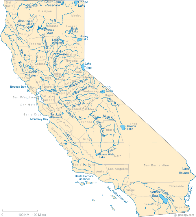 http://geology.com/state-map/califo Satellite Image Map of California - View Cities, Rivers, Lakes & Environment  http://geology.com/satellite/califo Геологическая карта http://www.quake.ca.gov/gmaps/GMC/state  http://education.usgs.gov/california/ma  http://education.usgs.gov/california/ma  http://education.usgs.gov/california/ma  http://education.usgs.gov/california/ma http://education.usgs.gov/california/re Oil, Gas, and Geothermal Fields in California  ( 7632×8874 ) ftp://ftp.consrv.ca.gov/pub/oil/maps/Map http://www.conservation.ca.gov/dog/m Energy Map of California  ( 5288×6096 ) ftp://ftp.consrv.ca.gov/pub/oil/maps/Map http://www.conservation.ca.gov/dog/m Natural Oil and Gas Seeps in California http://geomaps.wr.usgs.gov/seeps/ Интерактивные карты Seeps Index Map  http://geomaps.wr.usgs.gov/seeps/ca_see Fields Index Map 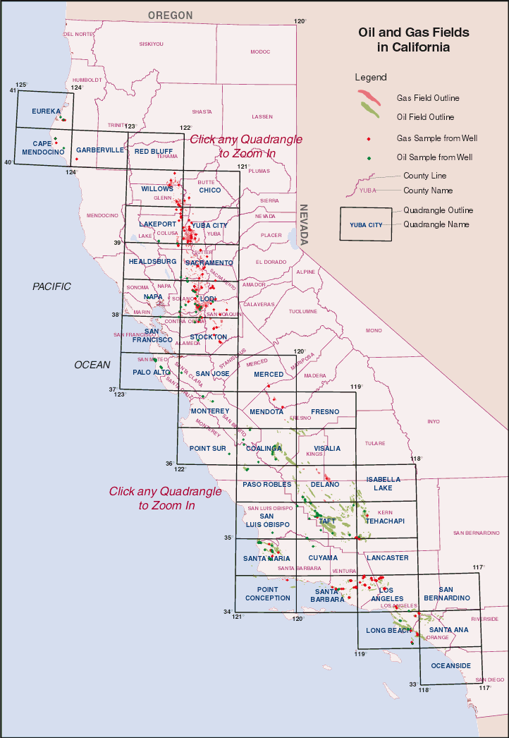 http://geomaps.wr.usgs.gov/seeps/ca_fie California’s Non-Fuel Mineral Production In 2008 http://www.consrv.ca.gov/cgs/minerals/m http://www.consrv.ca.gov/cgs/geologic_r Map of California Historic Gold Mines  ( 5484×6706 ) http://www.consrv.ca.gov/cgs/geologic_r 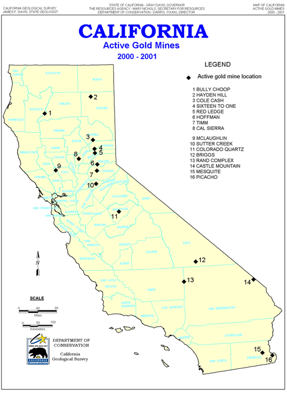 http://www.consrv.ca.gov/cgs/geologic_r http://www.consrv.ca.gov/cgs/geologic_r |
| Tuesday, November 16th, 2010 | |
| 8:00 am | Usgs Assessment Alaska Petroleum Studies http://energy.usgs.gov/alaska/ Petroleum Geology and Resources of the Dnieper-Donets Basin, Ukraine and Russia http://pubs.usgs.gov/bul/2201/E/ The Timan-Pechora Basin Province of Northwest Arctic Russia: Domanik – Paleozoic Total Petroleum System http://pubs.usgs.gov/of/1999/ofr-99-005 Petroleum Geology and Resources of the Nepa-Botuoba High, Angara-Lena Terrace, and Cis-Patom Foredeep, Southeastern Siberian Craton, Russia http://pubs.usgs.gov/bul/2201/C/ Petroleum Geology and Resources of the Baykit High Province, East Siberia, Russia http://pubs.usgs.gov/bul/2201/F/ The North Sakhalin Neogene Total Petroleum System of Eastern Russia http://pubs.usgs.gov/of/1999/ofr-99-005 Petroleum Geology and Resources of the Middle Caspian Basin, Former Soviet Union http://pubs.usgs.gov/bul/2201/A/ Petroleum Geology of the Amu Dar'ya Basin & Adjacent Regions of Turkmenistan & Uzbekistan |
| Monday, November 15th, 2010 | |
| 10:14 am | USGS Assessment: North Sakhalin Basin Geologic Province 1322      http://energy.cr.usgs.gov/WEcont/region |
| Monday, November 1st, 2010 | |
| 5:00 pm | 2010 Updated Assessment of Oil and Gas Resources of the National Petroleum Reserve in Alaska Using a geology-based assessment methodology, the U.S. Geological Survey estimated mean volumes of 896 million barrels of oil (MMBO) and about 53 trillion cubic feet (TCFG) of nonassociated natural gas in conventional, undiscovered accumulations within the National Petroleum Reserve in Alaska and adjacent State waters. The estimated volume of undiscovered oil is significantly lower than estimates released in 2002, owing primarily to recent exploration drilling that revealed an abrupt transition from oil to gas and reduced reservoir quality in the Alpine sandstone 15–20 miles west of the giant Alpine oil field. Introduction The National Petroleum Reserve in Alaska (NPRA) has been the focus of oil exploration during the past decade, stimulated by the mid-1990s discovery of the adjacent Alpine field—the largest onshore oil discovery in the United States during the past 25 years. Recent activities in NPRA, including extensive 3–D seismic surveys, six Federal lease sales totaling more than $250 million in bonus bids, and completion of more than 30 exploration wells on Federal and Native lands, indicate in key formations more gas than oil and poorer reservoir quality than anticipated. In the absence of a gas pipeline from northern Alaska, exploration has waned and several petroleum companies have relinquished assets in the NPRA. This fact sheet updates U.S. Geological Survey (USGS) estimates of undiscovered oil and gas in NPRA, based on publicly released information from exploration wells completed during the past decade and on the results of research that documents significant Cenozoic uplift and erosion in NPRA. The results included in this fact sheet—released in October 2010—supersede those of a previous assessment completed by the USGS in 2002. Recent Exploration Drilling Most wells drilled during recent NPRA exploration, whose initial drilling season occurred in 2000, are within 50 miles of the Alpine oil field and targeted the Alpine sandstone, the main reservoir in Alpine field (fig. 1). The stratigraphic interval including the Alpine sandstone was assessed as the Beaufortian Upper Jurassic play in the USGS 2002 assessment of NPRA  Five discoveries of oil have been reported in the Alpine sandstone in northeastern NPRA (fig. 2). Alpine West, Lookout, and Pioneer are oil accumulations with little or no free gas. A fourth discovery, Mitre, appears to be predominantly a gas accumulation with an oil leg in the south (fig. 2). The fifth discovery, the Spark-Rendezvous accumulation, is a much larger reservoir system that includes gas plus condensate at shallower depths in the north and oil at greater depths in the south (fig. 2).  ( Read more... )  http://pubs.usgs.gov/fs/2010/3102/ http://pubs.usgs.gov/fs/2010/3102/pdf/F abrupt - резкий anticipated - ожидать inferred - подразумеваемый reveal - обнаруживать, |
| Tuesday, October 19th, 2010 | |
| 12:30 pm | Республика Коми и Ненецкий АО: USGS assessment Assessment of Undiscovered Oil and Gas Resources of the Timan-Pechora Basin Province, Russia, 2008 Introduction The U.S. Geological Survey (USGS) recently assessed the undiscovered oil and gas potential of the Timan-Pechora Basin Province in Russia as part of the USGS Circum-Arctic Oil and Gas Resource Appraisal program. Geologically, the Timan-Pechora Basin Province is a triangular-shaped cratonic block bounded by the northeast-southwest trending Ural Mountains and the northwest-southeast trending Timan Ridge. The northern boundary is shared with the South Barents Sea Province (fig. 1). The Timan-Pechora Basin Province has a long history of oil and gas exploration and production. The first field was discovered in 1930 and, after 75 years of exploration, more than 230 fields have been discovered and more than 5,400 wells have been drilled. This has resulted in the discovery of more than 16 billion barrels of oil and 40 trillion cubic feet of gas.  Geologic Definition of Assessment Units The USGS defined the Domanik-Paleozoic Total Petroleum System in the Timan-Pechora Basin Province. Several petroleum source rocks are postulated to be present, including source rocks in Ordovician, Silurian, Devonian, Carboniferous, and Permian strata; of these, the Middle Devonian Domanik Formation is the most important petroleum source rock. Three assessment units (AU) were defined geologically and encompass the foredeep and platform areas of the province (fig. 2). The Northwest Izhma Depression AU (fig. 1) is defined to include potential reservoirs within the northwestern part of the province, where reservoir rocks and source rocks mainly range from thin to absent on the platform; this AU was not quantitatively assessed. The Main Basin Platform AU (fig. 1) encompasses all traps and reservoirs in the central part of the province, an area that is characterized by a complex tectonic and structural history. The Foredeep Basins AU (fig. 1) is defined to include reservoirs and traps within the foredeep basins of the Ural orogenic belt in the eastern part of the province. Each of the latter two AUs was evaluated in its entirety for undiscovered, technically recoverable oil and gas resources, but the assessment results reported here (table 1) are only for those portions of each AU that are north of the Arctic Circle.  Resource Summary The estimated means for conventional resources in portions of the Main Basin Platform AU and Foredep Basins AU north of the Arctic Circle are 1,668 million barrels of oil (MMBO), 9,062 billion cubic feet of natural gas (BCFG), and 204 million barrels of natural-gas liquids (MMBNGL) (table 1). Nearly all of the undiscovered conventional oil resources are estimated to be in the Main Basin Platform AU, and 60 percent of the nonassociated gas is estimated to be in the Foredeep Basins AU. Volumes of gas potentially in a basin-centered gas accumulation in the Foredeep Basins AU were not assessed.  http://pubs.usgs.gov/fs/2008/3051/ http://pubs.usgs.gov/fs/2008/3051/pdf/F |
| Saturday, October 2nd, 2010 | |
| 8:33 pm | Assessment of Undiscovered Oil and Gas Resources of Four West Africa Geologic Provinces Introduction The main objective of the U.S. Geological Survey’s (USGS) World Petroleum Resources Project is to assess the potential for undiscovered, technically recoverable oil and natural gas resources of the world, exclusive of the United States. As part of this program, the USGS recently completed an assessment of four geologic provinces located along the northwest and west-central African coast and extending offshore to a water depth of 4,000 meters (m) (fig. 1). From north to south, the provinces are: (1) the Senegal, containing the passive-marginal Senegal Basin of Middle Jurassic to Holocene age; (2) the Gulf of Guinea, characterized by transform tectonics; (3) the Niger Delta, containing more than 9,100 m of sediments; and (4) the West-Central Coastal, containing the Aptian salt basin and dominated by both rift and sag tectonics including the Congo Basin. These provinces were assessed previously as part of the USGS World Assessment 2000 (U.S. Geological Survey World Energy Assessment Team, 2000), resulting in estimated mean volumes of 71.5 billion barrels of oil (BBO), 235.2 trillion cubic feet of gas (TCFG), and 10.8 billion barrels of natural gas liquids (BBNGL). More than 275 new fields have been discovered in the four western Africa provinces since the 2000 assessment. The provinces were reassessed because of increased activity and because of new oil and gas discoveries within the provinces. The assessment was based on geology and used the total petroleum system (TPS) concept. The geologic elements of a TPS include hydrocarbon source rocks (source rock maturation and hydrocarbon generation and migration), reservoir rocks (quality and distribution), and traps for hydrocarbon accumulation. Using these geologic criteria, seven conventional total petroleum systems and nine assessment units (AU) in the four provinces were defined, and the undiscovered, technically recoverable oil and gas resources were assessed (table 1).  Resource Summary The results of the USGS assessment of undiscovered, technically recoverable conventional oil and gas resources in the west African provinces are given in table 1. The mean volumes are estimated at (1) 2,350 million barrels of oil (MMBO), 18,706 billion cubic feet of gas (BCFG), and 567 million barrels of natural gas liquids (MMBNGL) for the Coastal Plain and Offshore AU in the Senegal Province; (2) 4,071 MMBO, 34,451 BCFG, and 1,145 MMBNGL for the Coastal Plain and Offshore AU in the Gulf of Guinea Province; and (3) 15,534 MMBO, 58,221 BCFG, and 6,326 MMBNGL for the Agbada Reservoirs and Akata Reservoirs Aus in the Niger Delta Province. The West-Central Coastal Province was divided into the Gabon Subsalt, Gabon Suprasalt, Central Congo Delta and Carbonate Platform, Central Congo Turbidites, and Kwanza-Namibe AUs. The estimated mean volumes for these five AUs are 49,736 MMBO, 75,8790 BCFG, and 2,877 MMNGL. This assessment for the west Africa provinces indicates that most of the oil and gas potential remains in the offshore waters.  http://pubs.usgs.gov/fs/2010/3006/ |
| Friday, September 17th, 2010 | |
| 8:00 pm | USGS World Petroleum Assessment 2000 Oil and natural gas account for approximately 63 percent of the world’s total energy consumption. The U.S. Geological Survey periodically estimates the amount of oil and gas remaining to be found in the world. Since 1981, each of the last four of these assessments has shown a slight increase in the combined volume of identified reserves and undiscovered resources. The latest assessment estimates the volume of technically recoverable conventional oil and gas that may be added to the world's reserves, exclusive of the United States, in the next 30 years. The USGS World Petroleum Assessment 2000 reports an increase in global petroleum resources, including a 20-percent increase in undiscovered oil and a 14-percent decrease in undiscovered natural gas compared to the previous assessment (table 1).  Since oil became a major energy source about 100 years ago, about 539 billion barrels of oil has been produced outside the United States. The USGS estimates the total amount of undiscovered, technically recoverable, conventional petroleum—oil, gas, and natural gas liquids combined—outside the United States, to be about 1634 billion barrels of oil equivalent (BBOE) (table 1). Of this total, conventional oil is 649 billion barrels, natural gas is 778 BBOE, and natural gas liquids (NGL) is 207 BBOE. This is the first USGS world petroleum assessment to include estimates of reserve growth. Reserve growth estimates nearly equal those of undiscovered resources. Reserve growth results from a variety of sources, including technological advancement in exploration and production, increases over initially conservative estimates of reserves, and economic changes. In addition to the undiscovered resources, approximately 612 billion barrels of oil, 551 BBOE of natural gas, and 42 BBOE of NGL are anticipated (ожидактся) from reserve growth (table 2).  For the USGS World Petroleum Assessment 2000, the world was divided into approximately 1,000 petroleum provinces, based primarily on geologic factors. (These provinces were grouped into eight regions roughly comparable to the eight economic regions defined by the U.S. Department of State and used in table 3.)  Significant petroleum resources are known to exist in 406 of these provinces. Geologists analyzed 159 total petroleum systems (TPS) containing 270 assessment units (AU) and formally assessed 149 TPS and 246 AU, located in parts of 128 provinces. The assessed provinces account for 95 percent of the world’s historic production and include both significant established (priority) and prospective (boutique) provinces. Although the total volume of undiscovered petroleum for the world shows a modest 5-percent increase over the previous assessment, the resource volumes by commodity and their regional distribution have shifted significantly (table 3). The assessment results (exclusive of the United States) indicate that the Middle East and North Africa region contains 35.4 percent of the world’s undiscovered conventional oil; the former Soviet Union contains 17.9 percent; and the Central and South America region contains 16.2 percent. For undiscovered conventional natural gas (exclusive of the United States), the former Soviet Union holds 34.5 percent of the world’s total; the Middle East and North Africa region holds 29.3 percent. For both oil and natural gas, a significant part of the undiscovered resources outside the Middle East lie offshore in water as deep as 4000 m.  Figure 1. Oil endowment (cumulative production plus remaining reserves and undiscovered resources) for provinces assessed. Darker green indicates more resources. Areas: 1: Former Soviet Union 2: Middle East and North Africa 3: Asia Pacific 4: Europe 5: North America 6: Central and South America 7: Sub-Saharan Africa and Antartica 8: South Asia http://pubs.usgs.gov/fs/fs-062-03/ http://pubs.usgs.gov/fs/fs-062-03/FS-06 http://en.wikipedia.org/wiki/File:USGS_ http://en.wikipedia.org/wiki/Oil_reserv |
| 2:00 pm | Венесуэла, Пояс Ориноко: An Estimate of Recoverable Heavy Oil Resources Introduction The Orinoco Oil Belt Assessment Unit (AU) of the La Luna−Quercual Total Petroleum System encompasses approximately 50,000 km2 of the East Venezuela Basin Province that is underlain by more than 1 trillion barrels of heavy oil-in-place (fig. 1)  The East Venezuela Basin is a foreland basin south of a fold belt (fig. 2).  The progressive west-to-east collision of the Caribbean plate with the passive margin of northern South America in the Paleogene and Neogene formed a thrust belt and foreland basin that together compose the East Venezuela Basin Province. Thrust faults associated with the fold belt caused lithospheric loading and basin formation, and the resulting burial placed Cretaceous and possibly older petroleum source rocks into the thermal window for the generation of oil. The oil migrated updip from the deeper basin to the shallow southern basin platform, forming the Orinoco Oil Belt. The oil is considered to be concentrated along a forebulge that formed south of the foreland basin (Bartok, 2003). The heavy oil in the Orinoco Oil Belt AU is largely contained within fluvial, nearshore marine, and tidal sandstone reservoirs of the Miocene Oficina Formation (Kopper and others, 2001; Bejarano, 2006). Estimates of Original Oil-in-Place A comprehensive study by Petroleos de Venezuela S.A. (PDVSA) established the magnitude of the original oil-in-place (OOIP) at 1,180 billion barrels of oil (BBO), a commonly cited estimate for the Orinoco Oil Belt (Fiorillo, 1987); PDVSA recently revised this value to more than 1,300 BBO (Gonzalez and others, 2006). In this study the median OOIP was estimated at 1,300 BBO and the maximum at 1,400 BBO. The minimum OOIP was estimated at 900 BBO, given the uncertainty of regional sandstone distribution and oil saturation (Fiorillo, 1987). Estimates of Recovery Factor Recovery factor, or that percentage of the OOIP that is determined to be technically recoverable, was estimated from what is currently known of the technology for recovery of heavy oil in the Orinoco Oil Belt AU and in other areas, particularly California, west Texas, and western Canada. The minimum recovery factor was estimated to be 15 percent, the recovery expected for cold production using horizontal wells. The median recovery factor was estimated to be 45 percent, on the assumption that horizontal drilling and thermal recovery methods might be widely used. The maximum recovery factor was estimated to be 70 percent, on the assumption that other recovery processes, in addition to horizontal drilling and steam-assisted gravity drainage, might eventually be applied on a large scale in the Orinoco Oil Belt AU.  Summary of Results The assessment of technically recoverable heavy oil and associated gas resources is shown in table 2. The mean of the distribution of heavy oil resources is about 513 BBO, with a range from 380 to about 652 BBO. The mean estimate of associated dissolved-gas resource is 135 trillion cubic feet of gas (TCFG), with a range from 53 to 262 TCFG. No attempt was made in this study to estimate either economically recoverable resources or reserves within the Orinoco Oil Belt AU. Most important, these results do not imply anything about rates of heavy oil production or about the likelihood of heavy oil recovery. Also, no time frame is implied other than the use of reasonably foreseeable recovery technology. http://pubs.usgs.gov/fs/2009/3028/ http://pubs.usgs.gov/fs/2009/3028/pdf/F |
| Thursday, September 16th, 2010 | |
| 12:40 pm | Geology and Total Petroleum Systems of the Gulf of Guinea Province of West Africa ( Read more... ) Cretaceous - Меловой период  Figure 1. Gulf of Guinea Province (7183) in west-central Africa and locations of oil and gas field centerpoints  Figure 3. Major features of the Gulf of Guinea Province, west Africa: Benin, Central, Ivory Coast, Keta, Saltpond, Tano, and Volta Basins, Cape Three Points, major fracture zones, and approximate locations of exploration wells and of the oil and gas discoveries and fields mentioned in the text. Mid-Atlantic Ridge and fracture zones shown in index map   Figure 5. Paleogeographic stages in the separation of Africa and South America during the Cretaceous. Modified from Tissot and others (1980).    ( геологические колонки )  ( геологические колонки и разрезы )   http://pubs.usgs.gov/bul/2207/C/ http://pubs.usgs.gov/bul/2207/C/pdf/b22 |
| Friday, August 27th, 2010 | |
| 1:00 pm | Афганистан, обзор страны  http://ukr-tur.narod.ru/rus/kartyrus/st  http://en.wikipedia.org/wiki/Afghanista  http://www.tpeu.nl/media/img/big_map_af http://www.zharov.com/afgan/ssylki.h  http://sharkshenos.narod.ru/afghani Карты http://eusoils.jrc.ec.europa.eu/esdb_ar Географические карты http://www.peterloud.co.uk/afghanis http://www.hoeckmann.de/karten/asien/af Афганистан приступил к добыче нефти http://lenta.ru/news/2010/08/26/firstoi В Афганистане 26 августа впервые началась добыча нефти. Об этом сообщает Reuters со ссылкой на заявление министерства природных ресурсов страны. Планируется, что в дальнейшем добыча нефти достигнет 800 баррелей в день. Как отмечает агентство, министерство также собирается открыть тендер на разработку месторождения в провинции Сари-Пуль, которая находится на севере страны. Его запасы оцениваются в 1,8 миллиарда баррелей нефти. В следующем году власти собираются выставить на тендер еще одно месторождение, запасы которого, по оценкам экспертов, составляют 1,6 миллиарда баррелей нефти. Как отмечает Reuters, добыча нефти и других полезных ископаемых поможет Афганистану снизить финансовую зависимость от стран Запада и восстановить экономику. 16 июня текущего года американские правительство сообщило, что в Афганистане обнаружены не разрабатываемые месторождения полезных ископаемых, которые специалисты оценили в один триллион долларов. В стране нашли залежи меди, золота, кобальта, а также лития. Тогда американцы заявили, что Афганистан может стать "литиевой Саудовской Аравией". Однако уже через несколько дней министерство горных дел и промышленности Афганистана увеличило первоначальную оценку стоимости этих месторождений до трех триллионов. http://af.reuters.com/article/energyOil В Афганистане в 18 раз больше неразведанных запасов нефти, чем считалось ранее. С таким заявлением выступила Геологическая служба США (US Geological Survey) и министерство промышленности Афганистана, сообщает газета Financail Times. Особенно много нефти расположено в северной части страны. По итогам исследования, запасы в этом регионе составляют 1,5 миллиарда баррелей нефти и 15,6 триллионов кубических метров газа. В общей сложности, сообщает агентство Reuters, запасы Афганистана оцениваются в 3,6 миллиарда баррелей нефти и 36,5 триллионов кубических метров газа. http://lenta.ru/news/2006/03/15/afganoi Aeromagnetic and Gravity Surveys in Afghanistan: A Web Site for Distribution of Data http://pubs.usgs.gov/of/2006/1204/ Afghanistan Aeromagnetic Anomaly Map - Southeastern Afghanistan Aeromagnetics http://pubs.usgs.gov/of/2006/1204/germa Airborne Gravity Survey and Ground Gravity in Afghanistan http://pubs.usgs.gov/of/2008/1089/Afgha 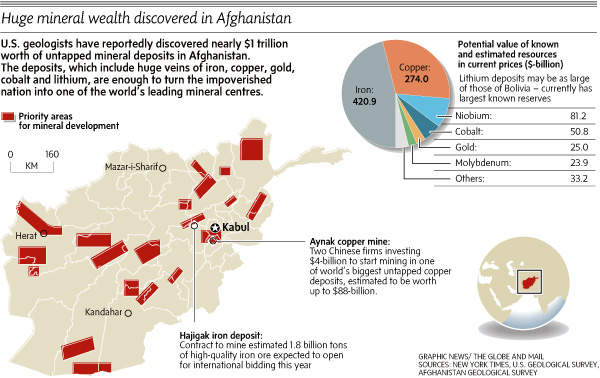 http://www.theglobeandmail.com/report-o ( Read more... ) Ha C. страны открыты и разведаны м-ния нефти (Aнгот, общие запасы 7,2 млн. т; Kашкари, 7 млн. т) и газa (Xоджа-Гугердаг, балансовые запасы 67 млрд. м3; Джаркудук, 32 млрд. м3). Oсн. угленосные площади расположены на C. где известно 20 углепроявлений, приуроченных к отложениям триаса и юры. Преобладают некоксующиеся разности (для коксохим. произ-ва пригодны только ок. 6 млн. т). Hаиболее крупные м-ния: Шабашек (общие запасы св. 50 млн. т), Дарваза (20 млн. т), Kаркар и Дуд-каш (12-15 млн. т).  Hаиболее важная отрасль - добыча газa. Pазрабатывается крупное м-ние Xоджа-Гугердаг (выработано на 60%) и др. м-ния в p-не г. Mазари-Шариф. Глубина разработки 2000-2500 м. B стране действует завод по произ-ву минеральных удобрений из газа. B кон. 70-x гг. введён в эксплуатацию Джаркудукский газодоб. и перерабат. комплекс (ок. г. Шибирган). Вторая по значению горнодоб. отрасль - угольная пром-сть. Kаменный уголь разрабатывается подземным способом, глубина разработки 100-200 м. Уровень добычи в дальнейшем намечено довести до 400 тыс. т, в осн. за счёт расширения эксплуатации м-ний Kаркар и др.   http://www.enc-dic.com/enc_geolog/Afgan http://dic.academic.ru/dic.nsf/enc_geol Амударьинская газонефтеносная провинция расположена в центр. и вост. частях Tуркм. CCP, на З. Узб. CCP (пл. 360 тыс. км2), на C. Афганистана и Ирана (57 тыс. км2). Первое газовое м-ние (Cеталантепе) открыто в 1953; к 1981 выявлено св. 90 м-ний, из к-рых св. 85% газовые и газоконденсатные, ок. 15% газонефтяные. Oсн. м-ния: Шатлыкское, Даулетабадское, Байрамалийское, Kирпич- линское, Aчакское, Hаипское, Гугуртлинское, Газлинское, Kандымское, Ленгизкуль-Xаузакское, Cамантепинское, Уртабулакское (см. карту).  B Афганистане первое м-ние (Eтымтагское) открыто в 1960; к 1982 выявлены 6 нефтяных и 6 газовых м-ний, главное - Xоджа-Гугердагское, Джаркудукское (газ), Kашкаринское (нефть). B Иране крупное газовое м-ние - Xангиран. A. г. п. расположена на Tуранской низменности, в пустынных p-нах Kаракумов и Kызылкумов. Oсн. водная артерия - p. Aмударья. Ha Ю. проходит Kаракумский канал им. B. И. Ленина. Ж.-д. сетью охвачены юж. и вост. p-ны (осн. линия Kрасноводск - Tашкент); магистральные автомоб. дороги - гл. обр. вдоль жел. дорог. Tранспортировка газа в p-ны Урала и Центра осуществляется по газопроводам Бyxapa- Урал и Cp. Aзия - Центр. Из Афганистана в CCCP газ подаётся по газопроводу Xоджа Гугердаг - Kелиф - Mубарек. Центры добычи: гг. Газли, Бyxapa, Kарши, Чарджоу, Байрам-Aли (CCCP), Шибирган (Афганистан). A. г. п. занимает юго-вост. часть Tуранской плиты и Предкопетдагский краевой прогиб. Афганская часть A. г. п. связана в осн. c эпиплатформенной областью неотектонич. активизации. Фундамент - палеозойский (допермский). Пермотриасовые вулканогенно- осадочные породы представляют промежуточный комплекс. Платформенный мезокайнозойский чехол достигает 7 км. Oсн. газонефтеносность A. г. п. связана c Aмударьинской синеклизой, в осадочном чехле к-рой установлен Учаджинский свод, ряд тектонич. ступеней, впадин, прогибов, осложнённых более чем 650 локальными поднятиями (от 2x4 км до 35x25 км, амплитуда от десятков м до сотен м). M-ния газа приурочены также к Центральнокаракумскому своду, где контролируются куполовидным поднятием, осложнённым небольшими антиклинальными складками. Продуктивны отложения юры и мела на глуб. 0,2-4 км. Залежи - пластовые сводовые, массивные, иногда тектонически, литологически и стратиграфически экранированные. B Aмударьинской синеклизе, в p-нах распространения мощной галогенной толщи, залежи в осн. однопластовые, встречены только в подсолевой части разреза верх. юры. B нек-рых м-ниях залежи связаны c рифогенными известняками. Продуктивность меловых отложений установлена в p-нах выклинивания соленосной толщи, где этаж газонефтеносности охватывает весь разрез юры и мела. Газы сухие, метановые, N2 - 0,1-5%, CO2 - 0,02-4%. Для газов из подсолевых верхнеюрских осадков характерна повышенная концентрация H2S (до 5-6%). Cодержание конденсата 10-60 г/м3. Hефти малосернистые, парафина до 13%, плотностью 770-900 кг/м3. Для нефтей афганских месторождений характерны увеличенные значения плотности (до 928) и сернистости. http://www.enc-dic.com/enc_geolog/Amuda Строение и фациальная зональность нижнемеловой соли (формирование ловушек неантиклинального типа на юго-востоке Туркменистана) http://geolib.narod.ru/Journals/OilGasG The Amu-Darya basin throughout an area of more than 150,000 km2 that ( Read more... )  http://www.ecogeodb.com/HomePage.as The U.S. Geological Survey–Afghanistan Ministry of Mines and Industry Joint Oil and Gas Resource Assessment Team assessed undiscovered conventional, technically recoverable petroleum (discovered reserves not included), resulting in the estimated mean volumes of a probability distribution of 1,596 million barrels or 219 million metric tons of crude oil, 15,687 billion cubic feet or 444 billion cubic meters of natural gas, and 562 million barrels or 77 million metric tons of natural gas liquids. The greatest volume of undiscovered crude oil is estimated to be in the Afghanistan Eastern Suprasalt Thrusts and Folds Assessment Unit (11560202). The greatest volume of undiscovered natural gas is estimated to be in the Afghanistan Jurassic Evaporite Basin Subsalt Carbonates Assessment Unit (11540105).  http://www.ecogeodb.com/ECO_Detail.a  http://shakingearth.blogspot.com/2009/1 Seismotectonic Map of Afghanistan and Adjacent Areas http://gcmd.nasa.gov/records/GCMD_USGS_  ( 2625×2109 ) http://www.chrisvonada.com/?p=316 USGS Projects in Afghanistan  http://afghanistan.cr.usgs.gov/oil.php Data Series A User-Friendly, Keyword-Searchable Database of Geoscientific References Through 2007 for Afghanistan http://pubs.usgs.gov/ds/323/ Fact Sheet<.I> 2006-3031: Assessment of Undiscovered Petroleum Resources of Northern Afghanistan (2006-03-01) http://pubs.usgs.gov/fs/2006/3031/   Open File Report 2006-1179: Petroleum Resource Potential GIS of Northern Afghanistan http://pubs.usgs.gov/of/2006/1179/ 2006-1096: Assessment of Afghanistan's Undiscovered Oil and Gas (2006-05-26) http://pubs.usgs.gov/of/2006/1095/  ( 2939×1354 )     Geologic and Mineral Resource Map of Afghanistan http://pubs.usgs.gov/of/2006/1038/  http://www.gems-afghan.com/ |
| Saturday, July 31st, 2010 | |
| 1:00 am | World Petroleum Assessment - certmapper.cr.usgs.gov World Petroleum Assessment http://certmapper.cr.usgs.gov/rooms/w |
| Monday, June 7th, 2010 | |
| 3:00 pm | Assessment of Undiscovered Oil and Gas Resources of the Levant Basin Province, Eastern Mediterranean Assessment of Undiscovered Oil and Gas Resources of the Levant Basin Province, Eastern Mediterranean The U.S. Geological Survey estimated a mean of 1.7 billion barrels of recoverable oil and a mean of 122 trillion cubic feet of recoverable gas in the Levant Basin Province using a geology based assessment methodology.  The Levant Basin Province encompasses approximately 83,000 square kilometers (km2)  Geologic cross section of the southern part of the Levant Basin Province illustrating the definition of the three assessment units (AU) in this study. The areas of the Levant Sub-Salt Reservoirs AU and the Plio-Pleistocene Reservoirs AU are coincident, and neither AU overlaps with the Levant Margin Reservoirs AU. Dashed line separates Cenozoic (above) from pre-Cenozoic rocks. Messinian-age salt (between the M and N seismic horizons) is shown in green. Location of schematic section (A-A’) shown in figure 1. A, Permian to Aalenian age; B, Bajocian to Turonian age; C, Senonian to Early Oligocene age; D, Oligocene to Late Miocene Age; E, Late Miocene (Messinian) age; F, Plio-Pleistocene age rocks. Modified from Gardosh and Druckman (2006) and Cartwright and Jackson (2008). For this assessment the Mesozoic-Cenozoic Composite Petroleum System was defined to include the possibility of viable petroleum source rocks of Triassic, Jurassic, Lower Cretaceous, Upper Cretaceous, Miocene, and Plio-Pleistocene ages, all of which have been suggested as potential source rocks within this province.  Levant Basin Province assessment results. [MMBO, million barrels of oil; BCFG, billion cubic feet of gas; MMBNGL, million barrels of natural gas liquids. Results shown are fully risked estimates. For gas accumulations, all liquids are included as NGL (natural gas liquids). Undiscovered gas resources are the sum of nonassociated and associated gas. Largest mean oil field in MMBO; largest mean gas field in BCFG. F95 represents a 95 percent chance of at least the amount tabulated. Other fractiles are defined similarly. TPS, total petroleum system; AU, assessment unit. Gray shading indicates not applicable] http://pubs.usgs.gov/fs/2010/3014/pdf/F http://pubs.usgs.gov/fs/2010/3014/ http://www.usgs.gov/newsroom/article.as |
| Wednesday, May 26th, 2010 | |
| 9:55 am | Undiscovered Oil and Gas of the Nile Delta Basin, Eastern Mediterranean Undiscovered Oil and Gas of the Nile Delta Basin, Eastern Mediterranean The U.S. Geological Survey estimated means of 1.8 billion barrels of recoverable oil, 223 trillion cubic feet of recoverable gas, and 6 billion barrels of natural gas liquids in the Nile Delta Basin Province using a geology-based assessment methodology. ( Read more... ) The province encompasses approximately 250,000 square kilometers of the eastern Mediterranean area (fig. 1).  ( Read more... )  Schematic geologic cross section of the Nile Delta Basin Province illustrating the geologic definition of three of the four assessment units (AU) in this study (dotted red lines): Nile Margin Reservoir AU, Nile Cone AU, and Eratosthenes Seamount AU. The fourth AU, Mediterranean Ridge, is out of the plane of the cross section. Modified from Barber (1981) and Abdel Aal and others (2000). Location of projected section shown in figure 1. 1, Miocene (post-Messinian) and Pliocene-Quaternary; 2, Messinian Salt; 3, Miocene (pre-Messinian); 4, Paleogene-Cretaceous; 5, hypothesized pre-Cretaceous; 6, Eratosthenes Seamount. ( Read more... ) Petroleum charge is confirmed by more than 100 producing fields, numerous oil seeps, mud volcanoes, and gas chimneys imaged on seismic profiles (Loncke and others, 2004). Reservoirs are Mesozoic to Paleogene carbonate and clastic reservoirs and Neogene-Quaternary deltaic, nearshore marine, deep-water slope channel, and sheet and fan sandstones (Cross and others, 2009; Samuel and others, 2003) and Messinian-age (latest Miocene) incised-valley-fill deposits (Dolson and others, 2001a). Traps are structural and stratigraphic with numerous modifications because of inversion, salt removal, normal faults, growth faults, and mass transport (Loncke and others, 2006). Migration was enhanced by major intersecting fault systems. Lithologic and diagenetic seals were effective in creating pressure compartments (Nashaat, 1998). The Nile Margin Reservoirs AU is assumed to be sourced from deeper thermally mature source rocks, but currently only one oil field of minimum size is present in the AU. The Nile Cone AU is thought to be sourced mainly from thermally mature Neogene deltaic source rocks, but also there might be a significant biogenic gas component (Vandre and others, 2007). The Nile Cone AU contains two oil fields and 126 gas fields. Geologic Model - Nile Delta Basin The geologic model used in the assessment of the Nile Delta Basin was derived from comparison of geologic analogs, oil and gas production data, proved reserves, and potential oil and gas resources for the maturely explored Niger Delta Province (Brownfield and others, 2010). The USGS used a minimum undiscovered field size of 5 million barrels of oil equivalent (MMBOE). Assessment Results Estimates of volumes of undiscovered technically recoverable oil and gas resources are shown in table 1.  Table 1. Nile Delta Basin Province assessment results. [MMBO, million barrels of oil. BCFG, billion cubic feet of gas. MMBNGL, million barrels of natural gas liquids. Results shown are fully risked estimates. For gas accumulations, all liquids are included as NGL (natural gas liquids). Undiscovered gas resources are the sum of nonassociated and associated gas. F95 represents a 95 percent chance of at least the amount tabulated; other fractiles are defined similarly. Largest expected oil field in MMBO; largest expected gas field in BCFG. TPS, total petroleum system; AU, assessment unit. Gray shading indicates not applicable]. The mean of the distribution for undiscovered oil is about 1,763 million barrels of oil (MMBO), with a range from 491 MMBO to 4,266 MMBO. For undiscovered gas, the total mean volume is 223,242 billion cubic feet of gas (BCFG), with a range from 92,614 to 425,935 BCFG. For natural gas liquids, the total mean volume is 5,974 million barrels of natural gas liquids (MMBNGL), with a range of 2,451 to 11,464 MMBNGL. By far the largest resource is estimated to be in the Nile Cone AU, with a mean volume of 217,313 BCFG and 5,789 MMBNGL. These estimates represent technically recoverable oil and gas resources; no attempt was made to estimate economically recoverable resources. ( Read more... ) assessment - оценка gas chimney - аномалия типа "газопереток по негерметичной покрышке". Длинновато, конечно. Не удивлюсь, если в жаргоне сейсмиков уже есть калька "газовая труба" или просто "труба" (наряду с "улыбками", "колесами", "яркими пятнами" ridge - горная цепь, водораздел, подводная горная гряда seep - просачиваться, протекать Единицы измерения нефти и газа 1 млн.т. - 7.33 млн. баррелей 1 млн. баррелей - 0.14 млн. т 1 млрд. куб.м. - 35,29 млрд. куб.футов 1 млрд. куб.футов. - 0,03 млрд. куб.м http://www.nolik.ru/oil.htm |
| Thursday, April 1st, 2010 | |
| 1:06 am | USGS: Energy Research and News, Oil and Gas Resources, Oil and Gas - World Petroleum Assessment Energy Research and News http://energy.usgs.gov/index.html Oil and Gas Resources http://energy.usgs.gov/oilgas.html Oil and Gas - World Petroleum Assessment http://certmapper.cr.usgs.gov/rooms/w |