| Time |
Event |
| 12:31a |
International Prefix: Yugoslavia’s Phone Code Breakup Mapped |
| 1:03a |
France’s Military Retreat from Africa Map |
| 1:03a |
|
| 2:16a |
Combined flag map of Roman and Alexander's Empires at their peaks |
| 2:45a |
What do you think about this version of Denmark? |
| 3:20a |
Ethnographic map of Southeast Europe late 19th century |
| 4:40a |
Map of the Proposed United States of Peru and Bolivia (1880–1881) ") | During the War of the Pacific (1879–1883), Peru and Bolivia—both struggling against Chile’s invasion—briefly explored a federal union known as the "United States of Peru and Bolivia." In June 1880, with Nicolás de Piérola as Peru’s leader and Narciso Campero leading Bolivia, they drafted a preliminary protocol for a federation to restore internal peace and strengthen their defense. However, the immense pressure of the war, lasting military defeats, and logistical collapse prevented a plebiscite or any serious implementation. The plan disappeared almost as quickly as it appeared, becoming just one more footnote in the complex history of Andean unity.
[link] [comments] | |
| 4:40a |
Map of the Peru–Bolivian Confederation (1836–1839) ") | The Peru-Bolivian Confederation existed from 1836 to 1839. It was an ambitious political union between Peru and Bolivia, aiming to strengthen both nations. However, internal divisions and external pressures — especially from Chile and Argentina — led to its collapse in just 3 years.
[link] [comments] | |
| 6:04a |
Religion in West Africa by Region (2020) |
| 6:04a |
Where state constitutions ban same-sex marriage |
| 6:30a |
|
| 7:48a |
|
| 8:17a |
Countries where men over 6'2 outnumber men under 5'5. |
| 9:32a |
Annual sunshine duration in Europe |
| 10:01a |
These regions account for 50% of world GDP |
| 12:03p |
Income inequality: Gini coefficient |
| 12:03p |
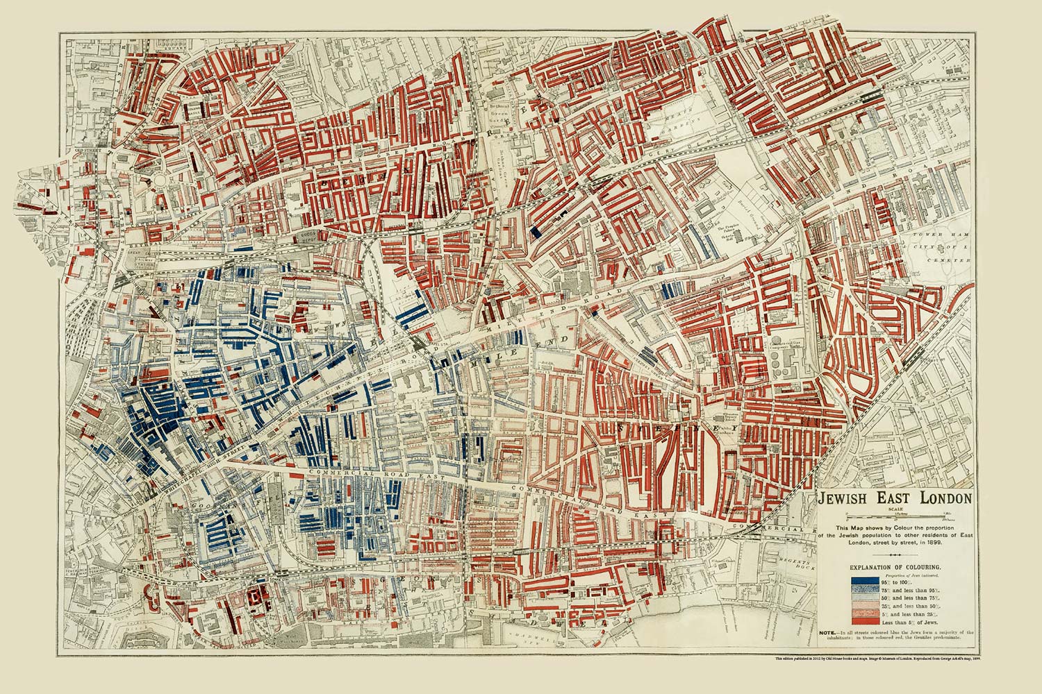
Jewish population in East London (1899 ) |
| 12:33p |
Birthplaces of All Winners of the Nobel Prize in Physics |
| 1:06p |
|
| 1:33p |
Latest ranking for countries by income by the World Bank  | This ranking is updated every July 1st. Costa Rica joins the group of high income contries for the first time joining Chile, Uruguay and Panama of Latin America in it. Cape Verde and Samoa also ascent to Upper Middle Income from Lower Middle Income, Namibia does the opposite being the only country that descents. The rest remain the same.
[link] [comments] | |
| 1:33p |
1920s Czech map of Europe, featuring the short-lived Ukrainian republic |
| 2:01p |
Withdrawal from the ottawa convention, to deploy landmines. |
| 3:16p |
US Coast Guard Geographical Operation Districts |
| 3:16p |
World Map Koppen Climate Classification |
| 4:33p |
Unemployment rates in May 2025. |
| 5:47p |
Number of Hindu Temples in the US |
| 5:47p |
Is the capital also the largest city in the country? |
| 6:19p |
Policital situation in Western Anatolia (1410) |
| 6:45p |
Literacy Rate of Indian state West Bengal & it's neighbouring country Bangladesh. |
| 6:45p |
|
| 7:16p |
2016 Democratic Presidential Primaries/Cacuses |
| 7:50p |
Percent of people in each region of Poland in December 1950 who had lived in the USSR (Former Eastern Poland) as of August 1939  as of August 1939") | Data from the Polish census of December 1950, question about place of residence in August 1939. Children born between 1939 and 1950 were counted according to their mother's place of residence in 1939.
[link] [comments] | |
| 8:16p |
U.S. Counties with active wind turbines |
| 8:46p |
Maximum Extent of Na-Dene-Yeniseian  | The recent article about the purported connection between Xiong-nu and Hunnish, and the supposition that they are both Yeniseian languages, made me think about the geographical extent of that language family. This map assumes that the following three hypotheses are true: --The Na-Deniseian-Yeniseian (NDY) language family is valid [the Vajda hypothesis]
--the Xiong-nu elite language and Hunnish were the same or closely related, and were Yeniseian or at least in the NDY family [the Bonmann-Fries hypothesis]
--The Arctic Small Tools Tradition (ASTT) people carried Na-Dene languages into North America [the Reich hypothesis] if all this is true, NDY languages were spoken from Greenland to Mexico and from Nebraska to Trieste (with a few short-lived communities elsewhere that I did not put on the map, like Florida and the South Pacific, although that was post-contact) although not co-terminously; therefore, I have labelled the map with very rough dates when an NDY is thought to have been spoken in an area.
[link] [comments] | |
| 8:46p |
Pangea, updated with current borders: |
| 9:18p |
How is the ocean warmer than all of Australia? |
| 9:18p |
Countries where men under 5'4 outnumber men over 5'8. |
| 10:33p |
|
| 10:33p |
|


")


")


")


![[link]](https://i.redd.it/jy12elg9dqaf1.jpeg)
![[link]](https://i.redd.it/i62pyoxtiqaf1.jpeg)
![[link]](https://i.redd.it/lp1792dhlqaf1.jpeg)
![[link]](https://i.redd.it/x4e2qqzktoaf1.png)
![[link]](https://i.redd.it/0357u7sfsqaf1.jpeg)
![[link]](https://i.redd.it/gdb6pm165raf1.jpeg)
![[link]](https://i.redd.it/o1hz56izzraf1.png)
![[link]](https://i.redd.it/sbhy97b9xraf1.jpeg)
![[link]](https://i.redd.it/rqn6o3tc3saf1.jpeg)
![[link]](https://i.redd.it/so8byypzlsaf1.png)
![[link]](https://i.redd.it/korezqz8rsaf1.png)
![[link]](https://i.redd.it/8kr5hzd5uraf1.png)
![[link]](https://i.redd.it/4b08u44e9taf1.jpeg)
![[link]](https://i.redd.it/kyfi5gfqdtaf1.png)
![[link]](https://i.redd.it/5rt5d5rgotaf1.png)
![[link]](https://i.redd.it/v6z738j8ztaf1.png)
![[link]](https://i.redd.it/jlxic0vtmolb1.png)
![[link]](https://i.redd.it/zppdyobgauaf1.png)
![[link]](https://i.redd.it/8cegbrnf9uaf1.png)
![[link]](https://i.redd.it/znzssxqyduaf1.jpeg)
![[link]](https://i.redd.it/pe6fs28xsuaf1.jpeg)
![[link]](https://i.redd.it/xdm2522aouaf1.png)
![[link]](https://i.redd.it/dzv5d9fjyuaf1.png)
![[link]](https://i.redd.it/2yve1388hvaf1.jpeg)
![[link]](https://i.redd.it/45689c6udvaf1.jpeg)
![[link]](https://i.redd.it/w0etzk2amvaf1.png)
![[link]](https://i.redd.it/u8hcsebxlvaf1.png)
![[link]](https://i.redd.it/j2mli2innvaf1.png)
![[link]](https://i.redd.it/cwymn7xyzvaf1.jpeg)
![[link]](https://i.redd.it/vd1f9wg63waf1.png)
![[link]](https://i.redd.it/gn8syzkudwaf1.png)
![[link]](https://i.redd.it/jm6wz6iszvaf1.png)
![[link]](https://i.redd.it/4tz6m5adfwaf1.jpeg)
![[link]](https://i.redd.it/tdt1s2tbkwaf1.jpeg)
![[link]](https://i.redd.it/uysapdm2kwaf1.png)
![[link]](https://i.redd.it/u86vx860qwaf1.jpeg)
![[link]](https://i.redd.it/gjrfxqieswaf1.jpeg)