Map Porn, for interesting maps' Journal
 
[Most Recent Entries] [Calendar View]

Saturday, September 6th, 2025

    Time Event
    12:16a
    US States by Percentage of Christians
    US States by Percentage of Christians

    Source: https://en.m.wikipedia.org/wiki/List_of_U.S._states_and_territories_by_religiosity

    81%+

    Mississippi: 87

    Alabama: 86

    Louisiana: 84

    Tennessee: 82

    76-80%+

    South Dakota: 79

    Texas: 78

    Arkansas: 78

    Georgia: 78

    Oklahoma: 78

    West Virginia: 78

    North Dakota: 77

    South Carolina: 77

    Iowa: 77

    Kansas: 76

    Nebraska: 76

    Missouri: 76

    North Carolina: 76

    71-75%

    New Mexico: 75

    Kentucky: 75

    Virginia: 74

    Rhode Island: 74

    Ohio- 74

    Minnesota: 73

    Utah: 73

    Pennsylvania: 72

    Indiana: 72

    Illinois: 71

    Wisconsin: 71

    Wyoming: 71

    61-70%

    Delaware: 70

    Florida: 70

    Michigan: 70

    Maryland: 69

    Connecticut: 69

    Idaho: 69

    New Jersey: 67

    Arizona: 67

    Nevada: 66

    Washington DC: 65

    Montana: 65

    Colorado: 64

    California: 63

    Hawaii: 63

    Alaska: 62

    Oregon: 61

    Washington: 61

    53-60%

    New York: 60

    Maine: 60

    New Hampshire: 59

    Massachusetts: 58

    Vermont: 53

    submitted by /u/Particular-Flan5721
    [link] [comments]
    2:18a
    Division of the Greater Middle East
    Division of the Greater Middle East

    These two linguistic cultural groupings provide a nice middle boundary in the geopolitical area known as the greater Middle East. The Arabian border is based on the Arab league, and there Perso-Turkic is based on countries that have an iranic/turkic language as a majority language, while also being influenced a lot by Turkic and Iranic cultures in their history.

    Now of course with such macro groupings there are bound to be nuances so let’s address some of them. In both groups you will find subdivisions that might belong to the other, especially at the borders such as the Kurdish people of Iraq or the Arabs of Ahvaz and Hatay. However I chose to go with the majority population of countries to enforce more rigid borders. Pakistan, Armenia and Georgia are also sometimes included in the great Middle East term, however linguistically they don’t really belong to either group, however they would be more linked to the Perso-Turkic grouping thanks to the cultural influence of Achamenids, Parthians, Sassanians and more on Armenian and Georgian cultures. Pakistan itself has many Iranic speakers such as Baloch and Pashto, and Urdu itself is very Persian influenced so it would fit as well. I chose not to show them however because I tried to be more rigid giving more weight to the linguistic majority.

    I also have to emphasize this isn’t merely a linguistic grouping but a historical and cultural too, as one can observe for Persianate societies and Arabized polities as well.

    submitted by /u/Extension-Beat7276
    [link] [comments]
    3:30a
    In what language is the name of each province/state of north america?
    In what language is the name of each province/state of north america? submitted by /u/Total-Ad-288
    [link] [comments]
    3:30a
    Share and number of foreign-born population in western european countries
    Share and number of foreign-born population in western european countries submitted by /u/vladgrinch
    [link] [comments]
    4:35a
    Life expectancy per state in the USA
    Life expectancy per state in the USA submitted by /u/cooliocoe
    [link] [comments]
    6:04a
    Places named Santa Cruz... move over Springfield!!
    Places named Santa Cruz... move over Springfield!! submitted by /u/sangamjb
    [link] [comments]
    7:16a
    All the roads in Canada (posted by Col. Chris Hadfield on FB)
    All the roads in Canada (posted by Col. Chris Hadfield on FB) submitted by /u/nthensome
    [link] [comments]
    7:52a
    The main channel of the Mississippi River highlighted in red on a map of all waterways in the contiguous USA.
    The main channel of the Mississippi River highlighted in red on a map of all waterways in the contiguous USA. submitted by /u/Different_Back_6173
    [link] [comments]
    9:02a
    Etymology map of pig
    Etymology map of pig submitted by /u/mapologic
    [link] [comments]
    9:02a
    The ethnic make-up of the Austrian empire in 1848 and the revolutions
    The ethnic make-up of the Austrian empire in 1848 and the revolutions submitted by /u/Rigolol2021
    [link] [comments]
    9:02a
    Countries with Nobel Peace Prize wins
    Countries with Nobel Peace Prize wins

    Nobel Peace Prize wins by country

    submitted by /u/TheGodTotem
    [link] [comments]
    9:32a
    European Countries with a Smaller Population than Istanbul
    European Countries with a Smaller Population than Istanbul submitted by /u/Perfect_Row_4751
    [link] [comments]
    10:03a
    Displaced % in Yugoslav wars
    Displaced % in Yugoslav wars submitted by /u/CompleteAnimal4606
    [link] [comments]
    11:18a
    Teams for U19 Cricket World Cup 2026
    Teams for U19 Cricket World Cup 2026 submitted by /u/APrimitiveMartian
    [link] [comments]
    11:47a
    Map of South America with flags
    Map of South America with flags submitted by /u/Sure_Secretary_446
    [link] [comments]
    11:47a
    A third of the US economy is ALREADY in recession...
    A third of the US economy is ALREADY in recession... submitted by /u/questison
    [link] [comments]
    1:01p
    countries that use fahrenheit vs celsius
    countries that use fahrenheit vs celsius

    Only America, Libera, Micronesia and Marshall Islands use fahrenheit.

    The rest of the world uses celsius

    The countries that use both are st kitts and nevis, antigua and barbuda, bahamas, belize and cyprus.

    submitted by /u/Karrot-guy
    [link] [comments]
    1:02p
    Monuments built by North Korea overseas
    Monuments built by North Korea overseas submitted by /u/APrimitiveMartian
    [link] [comments]
    1:33p
    China's economy is bigger than the combined economies of all the asian countries in red
    China's economy is bigger than the combined economies of all the asian countries in red submitted by /u/vladgrinch
    [link] [comments]
    2:46p
    Despite the housing shortage, In 85% of San Francisco Bay Area, it is illegal to build anything aside from Single Family Houses.
    Despite the housing shortage, In 85% of San Francisco Bay Area, it is illegal to build anything aside from Single Family Houses. submitted by /u/Mongooooooose
    [link] [comments]
    3:18p
    ONS cartogram showing the number of jobs around the UK
    ONS cartogram showing the number of jobs around the UK

    Dark red are highest paid, then light red, then grey, then light blue, then dark blue. The average job in dark red areas pays about double as much as the average job in dark blue areas.

    submitted by /u/AnonymousTimewaster
    [link] [comments]
    3:18p
    The World Painted map
    The World Painted map

    ???? Explore the map in detail, its making-of, and print editions: kontikimaps.com/worldpainted

    submitted by /u/n_slavin
    [link] [comments]
    4:33p
    Median age around the globe
    Median age around the globe submitted by /u/Strict_Weakness4159
    [link] [comments]
    4:33p
    The largest european ports in terms of annual cargo tonnage (in millions of tons)
    The largest european ports in terms of annual cargo tonnage (in millions of tons) submitted by /u/vladgrinch
    [link] [comments]
    5:01p
    Nunavut is the Largest Electoral District On Earth (8 Times Larger Than The UK)
    Nunavut is the Largest Electoral District On Earth (8 Times Larger Than The UK) submitted by /u/vladgrinch
    [link] [comments]
    5:01p
    1912 German federal election results [OC]
    1912 German federal election results [OC]

    Own work.

    Map outline and borders based upon https://commons.wikimedia.org/wiki/File:Karte\_Deutsches\_Reich,\_Verwaltungsgliederung\_1900-01-01.png.

    Source is Kaiserliches Statistisches Amt. (1913). Statistik des Deutschen Reichs: Die Reichstagswahlen von 1912 (Bd. 250). Berlin: Verlag von Puttkammer & Mühlbrecht. Retrieved from https://books.google.pl/books?id=CttLAAAAYAAJ.

    I decided to make my own map of at least one pre-WWI German election, as I couldn't find any modern maps even hinting to the fact that the German Empire used a two-round system, let alone displaying information about run-off results. I apologise for technical or visual shortcomings, this is my first election map.

    ***

    The final election in the German Reich before the Great War. All 397 members of the Reichstag were elected in single-member constituencies of varying size and population using the two-round system, also known as run-off voting, with universal male suffrage.

    Short and general descriptions of parties that won seats:

    • Social Democratic Party (SPD) - social democratic or socialist party of workers
    • Centre Party (ZENTRUM) - christian democratic party of Catholics
    • National-Liberal Party (NLP) - so-called right-liberal party
    • Progressive People's Party (FVP) - merger of so-called left-liberal parties
    • German-Conservative Party (DKP) - hard conservative party
    • German Reich Party (DRP) - moderate and liberal conservative party
    • Minority parties - summarised results of local regionalist parties or parties representing national minorities: Poles, Danes, Alsace-Lorraine, Hannover. Lithuanian candidate took part in run-off in Königsberg 1 (Memel), but was defeated by the National Liberal candidate. The German-Hanoverian Party was an agrarian party campaigning for Hanover's status as a federal state of Germany, rather than a province of Prussia.
    • Antisemites - various parties connected by their open antisemitism.
    • Peasant parties - local agrarian parties.
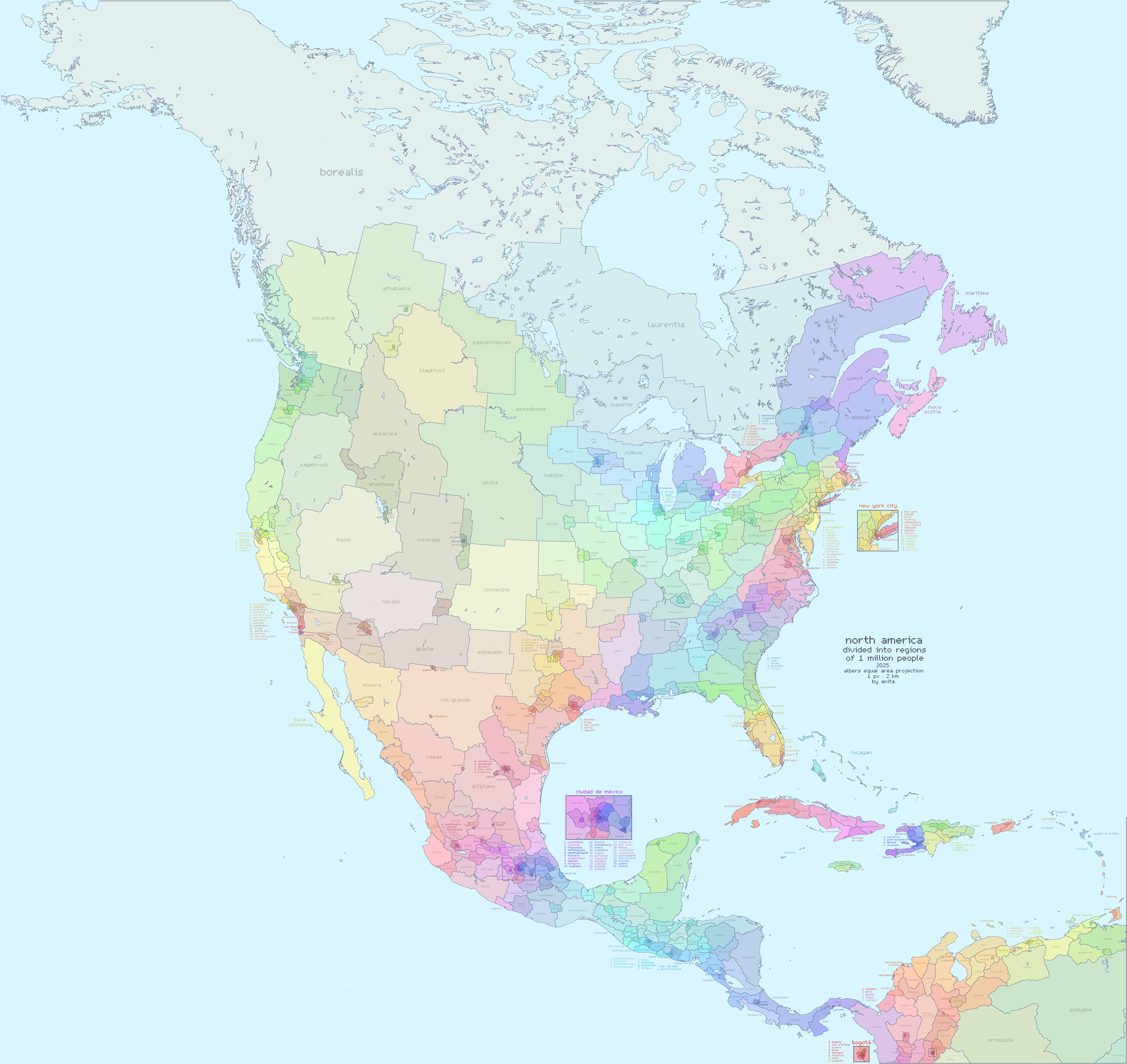
    submitted by /u/LoopMuhZoop
    [link] [comments]
    5:01p
    North America divided into regions of 1 million people
    North America divided into regions of 1 million people

    higher res image here! anita.garden/assets/na1m.png

    each region contains a million people, to within 5% of the last census or government published estimate.

    i drew the lines trying to respect:

    • 1 million people
    • urban/rural divide
    • linguistic boundaries
    • existing borders / admin divisions
    • native territories
    • mountain ranges
    • rivers

    the colors don't strictly mean anything, but within a general area the more saturated regions are usually denser.

    for the names, i tried to draw on a mix of rivers, cities, historical region names, native tribe names, mountains, depending on what i thought was closest to a shared characteristic of the whole region.

    the little '+'s are hypothetical capital cities.

    i used asesprite to draw. i used citypopulation.de for convenient access to subdivision census data. i used geopandas to draw the base reference map of coastlines and cities. reference shapefiles and city data are from naturalearthdata.com and simplemaps.com

    feedback is welcomed! let me know if you think i messed up where you live.

    you can check out my other maps at anita.garden/projects, i have done a europe 1 million map and more.

    submitted by /u/minecraftian48
    [link] [comments]
    5:32p
    The population of US states compared to their European counterparts
    The population of US states compared to their European counterparts submitted by /u/Courtelary
    [link] [comments]
    5:32p
    Brazilians Living in Europe in 2023
    Brazilians Living in Europe in 2023 submitted by /u/vladgrinch
    [link] [comments]
    6:03p
    Ethnic Changes in the Bosnian and Croatian Wars
    Ethnic Changes in the Bosnian and Croatian Wars

    Inspired by the absolutely terrible map posted (and deleted) earlier today, I tried to make a slightly better one.

    Sources:

    1. https://www.icty.org/x/cases/slobodan_milosevic/cis/en/cis_milosevic_slobodan_en.pdf
    2. https://www.hrw.org/news/2001/10/29/milosevic-important-new-charges-croatia
    3. https://www.hrw.org/reports/2003/croatia0903/
    4. https://docs.un.org/en/S/1996/1011
    5. https://www.unhcr.org/us/news/stories/home-again-10-years-after-croatias-operation-storm
    6. Eberhardt, Piotr. Ethnic Groups and Population Changes in Twentieth Century Eastern Europe: History, Data and Analysis, p. 406
    7. https://www.hlc-rdc.org/wp-content/uploads/2019/01/Dossier_Crimes_against_Croats_in_Vojvodina.pdf
    8. https://www.refworld.org/reference/countryrep/mrgi/2008/en/64980

    Edit:

    I should clarify some things. The numbers represent the amount of people displaced / lost from each ethnic group / territory. The percentage is the percentage of the pre-war population that was displaced (i.e. 523k Bosniaks from RS represent 91% of the pre-war Bosniak population in RS).

    RS - Republika Srpska, Serb controlled part of Bosnia

    HB - Herzeg-Bosnia, Croat controlled part of Bosnia

    RSK - Republika Srpska Krajina, Serb controlled part of Croatia

    Red - Croatia / Croat controlled

    Blue - Serbia / Serb controlled

    Yellow - Bosniak

    Striped - Minority groups

    submitted by /u/Loife1
    [link] [comments]
    6:32p
    Why is [country name] still ...
    Why is [country name] still ... submitted by /u/churiositas
    [link] [comments]
    7:00p
    How many times, each country was mentioned in the title of a post on r/MapPorn
    How many times, each country was mentioned in the title of a post on r/MapPorn submitted by /u/maps-and-potatoes
    [link] [comments]
    7:00p
    Bougainville, soon to be the newest nation in the world on September 2027
    Bougainville, soon to be the newest nation in the world on September 2027 submitted by /u/APrimitiveMartian
    [link] [comments]
    7:32p
    The Ottoman Empire in 1683
    The Ottoman Empire in 1683 submitted by /u/summus_rex_etruriae
    [link] [comments]
    7:32p
    Austria is the landlocked country with the most neighboring countries, 8.(Serbia also borders 8 countries if you include Kosovo, but that isn't in the UN)
    Austria is the landlocked country with the most neighboring countries, 8.(Serbia also borders 8 countries if you include Kosovo, but that isn't in the UN) submitted by /u/yphase
    [link] [comments]
    8:00p
    Pro-Israel Contributions To Elected Senators
    Pro-Israel Contributions To Elected Senators submitted by /u/VineMapper
    [link] [comments]
    8:32p
    Landlocked countries with a Navy
    Landlocked countries with a Navy submitted by /u/APrimitiveMartian
    [link] [comments]
    9:01p
    The genetic legacy of the Slavic expansion (black in the circle indicates Slavic heritage), Gretzinger et al. 2025
    The genetic legacy of the Slavic expansion (black in the circle indicates Slavic heritage), Gretzinger et al. 2025 submitted by /u/Ihoujin_
    [link] [comments]
    10:16p
    The Permanent Split of the Roman Empire in 395 AD (West vs East).
    The Permanent Split of the Roman Empire in 395 AD (West vs East). submitted by /u/Neat_Wrongdoer5176
    [link] [comments]
    10:48p
    Countries in Africa Where Local Football Clubs Are More Popular Than Foreign Teams.
    Countries in Africa Where Local Football Clubs Are More Popular Than Foreign Teams. submitted by /u/simbay2000
    [link] [comments]

    << Previous Day 2025/09/06
    [Calendar]
    Next Day >>

Map Porn, for interesting maps   About LJ.Rossia.org